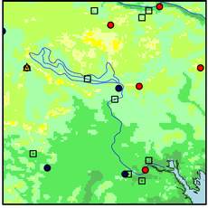
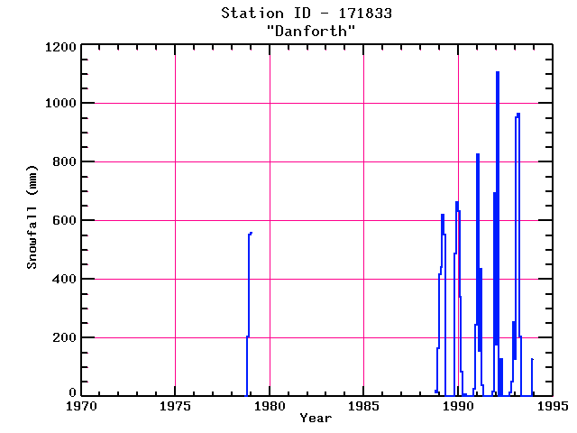
DANFORTH
| Name: | DANFORTH |
Lattitude: | 45.67 |
|---|
| Station ID: | 171833 |
Longitude: | -67.88 |
|---|
| Data Type: | Snowfall (mm) |
Elevation: | 115.8 (m) |
|---|
| Data Source: | NCDC |
Beginning Year: | 1978 |
|---|
| State / Province: | ME |
Ending Year: | Present |
|---|
| Other Close Sites |
|---|
| Data Type | PointID |
Name |
|---|
| Air Temperature (C) |
171833 |
DANFORTH |
| Precipitation (mm) |
171833 |
DANFORTH |
Station Data File:
| Point Id | Year | Snowfall mm |
|---|
| Jan |
Feb |
Mar |
Apr |
May |
Jun |
Jul |
Aug |
Sep |
Oct |
Nov |
Dec |
| 171833 |
1970 |
|
|
|
|
|
|
|
|
|
|
|
|
| 171833 |
1971 |
|
|
|
|
|
|
|
|
|
|
|
|
| 171833 |
1972 |
|
|
|
|
|
|
|
|
|
|
|
|
| 171833 |
1973 |
|
|
|
|
|
|
|
|
|
|
|
|
| 171833 |
1974 |
|
|
|
|
|
|
|
|
|
|
|
|
| 171833 |
1975 |
|
|
|
|
|
|
|
|
|
|
|
|
| 171833 |
1976 |
|
|
|
|
|
|
|
|
|
|
|
|
| 171833 |
1977 |
|
|
|
|
|
|
|
|
|
|
|
|
| 171833 |
1978 |
|
|
|
|
|
|
|
|
|
|
203 |
554 |
| 171833 |
1979 | 559 |
|
|
|
|
|
|
|
|
|
|
|
| 171833 |
1980 |
|
|
|
|
|
|
|
|
|
|
|
|
| 171833 |
1981 |
|
|
|
|
|
|
|
|
|
|
|
|
| 171833 |
1982 |
|
|
|
|
|
|
|
|
|
|
|
|
| 171833 |
1983 |
|
|
|
|
|
|
|
|
|
|
|
|
| 171833 |
1984 |
|
|
|
|
|
|
|
|
|
|
|
|
| 171833 |
1985 |
|
|
|
|
|
|
|
|
|
|
|
|
| 171833 |
1986 |
|
|
|
|
|
|
|
|
|
|
|
|
| 171833 |
1987 |
|
|
|
|
|
|
|
|
|
|
|
|
| 171833 |
1988 |
|
|
|
|
|
|
|
|
|
20 |
13 |
165 |
| 171833 |
1989 | 417 |
442 |
620 |
554 |
|
|
|
|
|
|
488 |
663 |
| 171833 |
1990 | 632 |
340 |
84 |
|
8 |
|
|
|
|
|
25 |
244 |
| 171833 |
1991 | 826 |
155 |
434 |
38 |
|
|
|
|
|
|
18 |
693 |
| 171833 |
1992 | 178 |
1107 |
|
127 |
|
|
|
|
|
13 |
51 |
254 |
| 171833 |
1993 | 127 |
952 |
965 |
203 |
|
|
|
|
|
|
|
127 |