DANFORTH
| Name: | DANFORTH |
Lattitude: | 45.67 |
|---|
| Station ID: | 171833 |
Longitude: | -67.88 |
|---|
| Data Type: | Precipitation (mm) |
Elevation: | 115.8 (m) |
|---|
| Data Source: | NCDC |
Beginning Year: | 1978 |
|---|
| State / Province: | ME |
Ending Year: | Present |
|---|
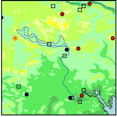
| Other Close Sites |
|---|
| Data Type | PointID |
Name |
|---|
| Air Temperature (C) |
171833 |
DANFORTH |
| Snowfall (mm) |
171833 |
DANFORTH |
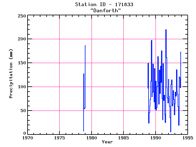
Station Data File:
| Point Id | Year | PPT mm |
|---|
| Jan |
Feb |
Mar |
Apr |
May |
Jun |
Jul |
Aug |
Sep |
Oct |
Nov |
Dec |
| 171833 |
1970 |
|
|
|
|
|
|
|
|
|
|
|
|
| 171833 |
1971 |
|
|
|
|
|
|
|
|
|
|
|
|
| 171833 |
1972 |
|
|
|
|
|
|
|
|
|
|
|
|
| 171833 |
1973 |
|
|
|
|
|
|
|
|
|
|
|
|
| 171833 |
1974 |
|
|
|
|
|
|
|
|
|
|
|
|
| 171833 |
1975 |
|
|
|
|
|
|
|
|
|
|
|
|
| 171833 |
1976 |
|
|
|
|
|
|
|
|
|
|
|
|
| 171833 |
1977 |
|
|
|
|
|
|
|
|
|
|
|
|
| 171833 |
1978 |
|
|
|
|
|
|
|
|
7 |
127 |
54 |
55 |
| 171833 |
1979 | 186 |
|
|
|
|
|
|
|
|
|
|
|
| 171833 |
1980 |
|
|
|
|
|
|
|
|
|
|
|
|
| 171833 |
1981 |
|
|
|
|
|
|
|
|
|
|
|
|
| 171833 |
1982 |
|
|
|
|
|
|
|
|
|
|
|
|
| 171833 |
1983 |
|
|
|
|
|
|
|
|
|
|
|
|
| 171833 |
1984 |
|
|
|
|
|
|
|
|
|
|
|
|
| 171833 |
1985 |
|
|
|
|
|
|
|
|
|
|
|
|
| 171833 |
1986 |
|
|
|
|
|
|
|
|
|
|
|
|
| 171833 |
1987 |
|
|
|
|
|
|
|
|
|
|
|
|
| 171833 |
1988 |
|
|
|
|
|
|
|
|
|
97 |
149 |
24 |
| 171833 |
1989 | 46 |
60 |
74 |
112 |
197 |
79 |
88 |
148 |
89 |
68 |
138 |
54 |
| 171833 |
1990 | 112 |
52 |
57 |
101 |
163 |
110 |
64 |
135 |
86 |
143 |
110 |
175 |
| 171833 |
1991 | 75 |
31 |
148 |
71 |
82 |
42 |
25 |
220 |
161 |
98 |
76 |
66 |
| 171833 |
1992 | 116 |
80 |
59 |
35 |
5 |
105 |
114 |
60 |
64 |
92 |
73 |
41 |
| 171833 |
1993 | 64 |
89 |
80 |
135 |
91 |
85 |
58 |
19 |
121 |
119 |
98 |
173 |