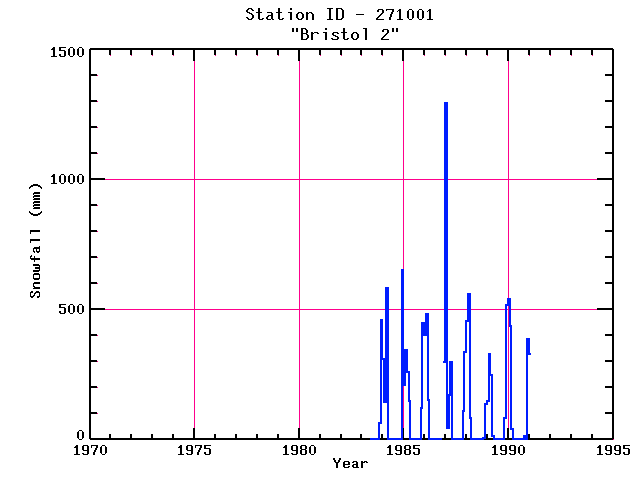
BRISTOL 2
| Name: | BRISTOL 2 |
Lattitude: | 43.58 |
|---|
| Station ID: | 271001 |
Longitude: | -71.73 |
|---|
| Data Type: | Snowfall (mm) |
Elevation: | 179.8 (m) |
|---|
| Data Source: | NCDC |
Beginning Year: | 1981 |
|---|
| State / Province: | NH |
Ending Year: | 1991 |
|---|
| Other Close Sites |
|---|
| Data Type | PointID |
Name |
|---|
| Precipitation (mm) |
271001 |
BRISTOL 2 |
Station Data File:
| Point Id | Year | Snowfall mm |
|---|
| Jan |
Feb |
Mar |
Apr |
May |
Jun |
Jul |
Aug |
Sep |
Oct |
Nov |
Dec |
| 271001 |
1970 |
|
|
|
|
|
|
|
|
|
|
|
|
| 271001 |
1971 |
|
|
|
|
|
|
|
|
|
|
|
|
| 271001 |
1972 |
|
|
|
|
|
|
|
|
|
|
|
|
| 271001 |
1973 |
|
|
|
|
|
|
|
|
|
|
|
|
| 271001 |
1974 |
|
|
|
|
|
|
|
|
|
|
|
|
| 271001 |
1975 |
|
|
|
|
|
|
|
|
|
|
|
|
| 271001 |
1976 |
|
|
|
|
|
|
|
|
|
|
|
|
| 271001 |
1977 |
|
|
|
|
|
|
|
|
|
|
|
|
| 271001 |
1978 |
|
|
|
|
|
|
|
|
|
|
|
|
| 271001 |
1979 |
|
|
|
|
|
|
|
|
|
|
|
|
| 271001 |
1980 |
|
|
|
|
|
|
|
|
|
|
|
|
| 271001 |
1981 |
|
|
|
|
|
|
|
|
|
|
|
|
| 271001 |
1982 |
|
|
|
|
|
|
|
|
|
|
|
|
| 271001 |
1983 |
|
|
|
|
|
|
|
|
|
|
64 |
460 |
| 271001 |
1984 | 310 |
145 |
582 |
|
|
|
|
|
|
|
|
650 |
| 271001 |
1985 | 211 |
345 |
259 |
147 |
|
|
|
|
|
|
122 |
447 |
| 271001 |
1986 | 401 |
483 |
152 |
|
|
|
|
|
|
|
|
300 |
| 271001 |
1987 | 1293 |
46 |
170 |
300 |
|
|
|
|
|
|
109 |
335 |
| 271001 |
1988 | 455 |
561 |
84 |
|
|
|
|
|
|
|
5 |
137 |
| 271001 |
1989 | 147 |
330 |
249 |
13 |
|
|
|
|
|
|
81 |
516 |
| 271001 |
1990 | 538 |
437 |
41 |
|
|
|
|
|
|
13 |
|
386 |
| 271001 |
1991 | 330 |
|
|
|
|
|
|
|
|
|
|
|
| 271001 |
1992 |
|
|
|
|
|
|
|
|
|
|
|
|
| 271001 |
1993 |
|
|
|
|
|
|
|
|
|
|
|
|