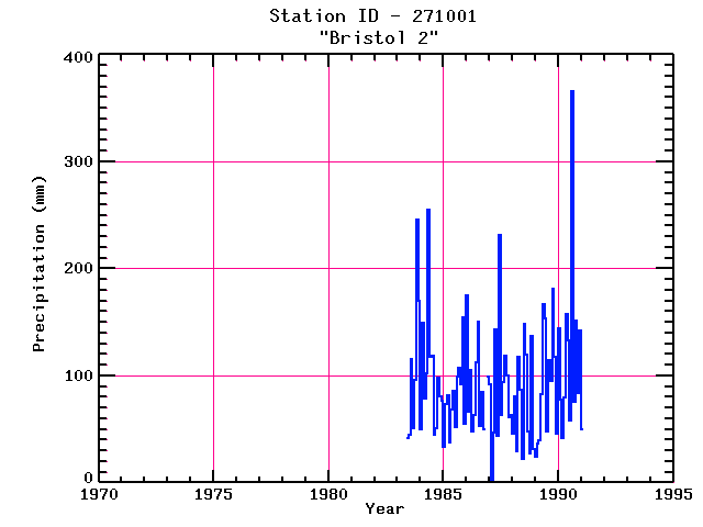
BRISTOL 2
| Name: | BRISTOL 2 |
Lattitude: | 43.58 |
|---|
| Station ID: | 271001 |
Longitude: | -71.73 |
|---|
| Data Type: | Precipitation (mm) |
Elevation: | 179.8 (m) |
|---|
| Data Source: | NCDC |
Beginning Year: | 1981 |
|---|
| State / Province: | NH |
Ending Year: | 1991 |
|---|
| Other Close Sites |
|---|
| Data Type | PointID |
Name |
|---|
| Snowfall (mm) |
271001 |
BRISTOL 2 |
Station Data File:
| Point Id | Year | PPT mm |
|---|
| Jan |
Feb |
Mar |
Apr |
May |
Jun |
Jul |
Aug |
Sep |
Oct |
Nov |
Dec |
| 271001 |
1970 |
|
|
|
|
|
|
|
|
|
|
|
|
| 271001 |
1971 |
|
|
|
|
|
|
|
|
|
|
|
|
| 271001 |
1972 |
|
|
|
|
|
|
|
|
|
|
|
|
| 271001 |
1973 |
|
|
|
|
|
|
|
|
|
|
|
|
| 271001 |
1974 |
|
|
|
|
|
|
|
|
|
|
|
|
| 271001 |
1975 |
|
|
|
|
|
|
|
|
|
|
|
|
| 271001 |
1976 |
|
|
|
|
|
|
|
|
|
|
|
|
| 271001 |
1977 |
|
|
|
|
|
|
|
|
|
|
|
|
| 271001 |
1978 |
|
|
|
|
|
|
|
|
|
|
|
|
| 271001 |
1979 |
|
|
|
|
|
|
|
|
|
|
|
|
| 271001 |
1980 |
|
|
|
|
|
|
|
|
|
|
|
|
| 271001 |
1981 |
|
|
|
|
|
|
|
|
|
|
|
|
| 271001 |
1982 |
|
|
|
|
|
|
|
|
|
|
|
|
| 271001 |
1983 |
|
|
|
|
|
42 |
44 |
115 |
51 |
96 |
246 |
170 |
| 271001 |
1984 | 50 |
149 |
78 |
102 |
254 |
117 |
119 |
45 |
50 |
98 |
81 |
76 |
| 271001 |
1985 | 33 |
74 |
82 |
37 |
68 |
86 |
52 |
99 |
107 |
92 |
154 |
55 |
| 271001 |
1986 | 175 |
66 |
105 |
48 |
63 |
112 |
150 |
53 |
85 |
49 |
|
99 |
| 271001 |
1987 | 91 |
3 |
47 |
143 |
43 |
232 |
63 |
94 |
118 |
100 |
61 |
63 |
| 271001 |
1988 | 46 |
81 |
29 |
118 |
87 |
22 |
149 |
120 |
48 |
27 |
137 |
31 |
| 271001 |
1989 | 24 |
36 |
39 |
82 |
167 |
153 |
48 |
115 |
95 |
181 |
118 |
46 |
| 271001 |
1990 | 144 |
77 |
41 |
79 |
158 |
133 |
58 |
366 |
76 |
151 |
83 |
142 |
| 271001 |
1991 | 49 |
|
|
|
|
|
|
|
|
|
|
|
| 271001 |
1992 |
|
|
|
|
|
|
|
|
|
|
|
|
| 271001 |
1993 |
|
|
|
|
|
|
|
|
|
|
|
|