 |
 |
|
|
|
|
| Name: | WEST GROTON | Lattitude: | 42.62 |
|---|---|---|---|
| Station ID: | 199226 | Longitude: | -71.63 |
| Data Type: | Snowfall (mm) | Elevation: | 103.9 (m) |
| Data Source: | NCDC | Beginning Year: | 1974 |
| State / Province: | MA | Ending Year: | 1987 |
| Other Close Sites | ||
|---|---|---|
| Data Type | PointID | Name |
| Stream Discharge (cms) | 01096000 | Squannacook River Near West Groton, Ma |
| Precipitation (mm) | 199226 | WEST GROTON |
| Download | |
|---|---|
| Site Descriptor Information | Site Time Series Data |
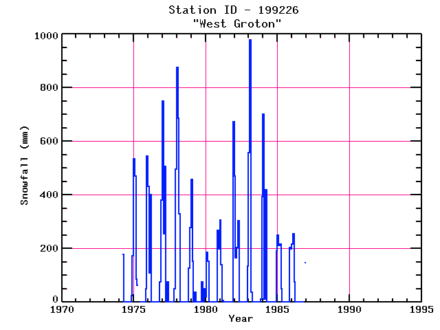
| Point Id | Year | Snowfall mm | |||||||||||
|---|---|---|---|---|---|---|---|---|---|---|---|---|---|
| Jan | Feb | Mar | Apr | May | Jun | Jul | Aug | Sep | Oct | Nov | Dec | ||
| 199226 | 1970 | ||||||||||||
| 199226 | 1971 | ||||||||||||
| 199226 | 1972 | ||||||||||||
| 199226 | 1973 | ||||||||||||
| 199226 | 1974 | 178 | 25 | 173 | |||||||||
| 199226 | 1975 | 533 | 470 | 86 | 64 | 51 | 546 | ||||||
| 199226 | 1976 | 432 | 109 | 401 | 76 | 381 | |||||||
| 199226 | 1977 | 749 | 254 | 506 | 76 | 51 | 495 | ||||||
| 199226 | 1978 | 876 | 686 | 330 | 127 | 279 | |||||||
| 199226 | 1979 | 457 | 152 | 38 | 76 | 51 | |||||||
| 199226 | 1980 | 20 | 185 | 152 | 267 | 198 | |||||||
| 199226 | 1981 | 307 | 140 | 8 | 673 | ||||||||
| 199226 | 1982 | 470 | 165 | 203 | 305 | 135 | |||||||
| 199226 | 1983 | 559 | 978 | 38 | 13 | 394 | |||||||
| 199226 | 1984 | 701 | 13 | 419 | 190 | ||||||||
| 199226 | 1985 | 249 | 211 | 216 | 51 | 203 | 198 | ||||||
| 199226 | 1986 | 216 | 254 | 76 | 147 | ||||||||
| 199226 | 1987 | ||||||||||||
| 199226 | 1988 | ||||||||||||
| 199226 | 1989 | ||||||||||||
| 199226 | 1990 | ||||||||||||
| 199226 | 1991 | ||||||||||||
| 199226 | 1992 | ||||||||||||
| 199226 | 1993 | ||||||||||||


