 |
 |
|
|
|
|
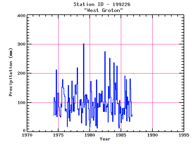
| Name: | WEST GROTON | Lattitude: | 42.62 |
|---|---|---|---|
| Station ID: | 199226 | Longitude: | -71.63 |
| Data Type: | Precipitation (mm) | Elevation: | 103.9 (m) |
| Data Source: | NCDC | Beginning Year: | 1974 |
| State / Province: | MA | Ending Year: | 1987 |
| Other Close Sites | ||
|---|---|---|
| Data Type | PointID | Name |
| Stream Discharge (cms) | 01096000 | Squannacook River Near West Groton, Ma |
| Snowfall (mm) | 199226 | WEST GROTON |
| Download | |
|---|---|
| Site Descriptor Information | Site Time Series Data |
| Point Id | Year | PPT mm | |||||||||||
|---|---|---|---|---|---|---|---|---|---|---|---|---|---|
| Jan | Feb | Mar | Apr | May | Jun | Jul | Aug | Sep | Oct | Nov | Dec | ||
| 199226 | 1970 | ||||||||||||
| 199226 | 1971 | ||||||||||||
| 199226 | 1972 | ||||||||||||
| 199226 | 1973 | ||||||||||||
| 199226 | 1974 | 57 | 117 | 104 | 58 | 60 | 212 | 52 | 72 | 133 | |||
| 199226 | 1975 | 131 | 85 | 73 | 54 | 51 | 96 | 85 | 154 | 179 | 150 | 149 | 128 |
| 199226 | 1976 | 120 | 72 | 78 | 77 | 68 | 18 | 102 | 159 | 48 | 116 | 37 | 73 |
| 199226 | 1977 | 93 | 65 | 174 | 114 | 70 | 122 | 70 | 97 | 161 | 134 | 128 | 164 |
| 199226 | 1978 | 219 | 76 | 78 | 57 | 79 | 109 | 91 | 111 | 30 | 80 | 65 | 100 |
| 199226 | 1979 | 301 | 83 | 94 | 123 | 128 | 22 | 127 | 113 | 99 | 110 | 78 | 40 |
| 199226 | 1980 | 16 | 30 | 173 | 137 | 48 | 90 | 102 | 40 | 53 | 83 | 117 | 21 |
| 199226 | 1981 | 22 | 178 | 13 | 97 | 84 | 83 | 132 | 86 | 103 | 130 | 102 | 140 |
| 199226 | 1982 | 123 | 103 | 69 | 95 | 70 | 275 | 104 | 68 | 89 | 85 | 96 | 33 |
| 199226 | 1983 | 156 | 114 | 252 | 178 | 118 | 66 | 58 | 99 | 35 | 111 | 237 | 163 |
| 199226 | 1984 | 59 | 168 | 145 | 109 | 225 | 96 | 97 | 23 | 13 | 107 | 63 | 86 |
| 199226 | 1985 | 31 | 58 | 80 | 43 | 64 | 82 | 59 | 191 | 139 | 80 | 179 | 38 |
| 199226 | 1986 | 119 | 93 | 105 | 48 | 35 | 181 | 147 | 103 | 53 | 58 | 200 | |
| 199226 | 1987 | ||||||||||||
| 199226 | 1988 | ||||||||||||
| 199226 | 1989 | ||||||||||||
| 199226 | 1990 | ||||||||||||
| 199226 | 1991 | ||||||||||||
| 199226 | 1992 | ||||||||||||
| 199226 | 1993 | ||||||||||||


