 |
 |
|
|
|
|
| Name: | WEST PARIS | Lattitude: | 44.33 |
|---|---|---|---|
| Station ID: | 179538 | Longitude: | -70.58 |
| Data Type: | Snowfall (mm) | Elevation: | 164.6 (m) |
| Data Source: | NCDC | Beginning Year: | 1966 |
| State / Province: | ME | Ending Year: | Present |
| Other Close Sites | ||
|---|---|---|
| Data Type | PointID | Name |
| Stream Discharge (cms) | 01057000 | Little Androscoggin River Near South Paris, Me |
| Precipitation (mm) | 179538 | WEST PARIS |
| Download | |
|---|---|
| Site Descriptor Information | Site Time Series Data |
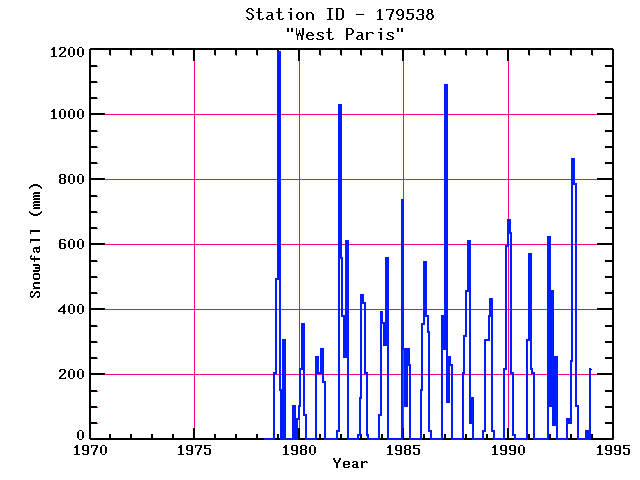
| Point Id | Year | Snowfall mm | |||||||||||
|---|---|---|---|---|---|---|---|---|---|---|---|---|---|
| Jan | Feb | Mar | Apr | May | Jun | Jul | Aug | Sep | Oct | Nov | Dec | ||
| 179538 | 1970 | ||||||||||||
| 179538 | 1971 | ||||||||||||
| 179538 | 1972 | ||||||||||||
| 179538 | 1973 | ||||||||||||
| 179538 | 1974 | ||||||||||||
| 179538 | 1975 | ||||||||||||
| 179538 | 1976 | ||||||||||||
| 179538 | 1977 | ||||||||||||
| 179538 | 1978 | 203 | 495 | ||||||||||
| 179538 | 1979 | 1194 | 152 | 305 | 102 | 64 | |||||||
| 179538 | 1980 | 102 | 216 | 356 | 76 | 254 | 203 | ||||||
| 179538 | 1981 | 203 | 279 | 178 | 25 | 1029 | |||||||
| 179538 | 1982 | 559 | 381 | 254 | 610 | 15 | 127 | ||||||
| 179538 | 1983 | 444 | 419 | 203 | 13 | 76 | 394 | ||||||
| 179538 | 1984 | 358 | 292 | 559 | 737 | ||||||||
| 179538 | 1985 | 279 | 102 | 279 | 229 | 152 | 356 | ||||||
| 179538 | 1986 | 546 | 381 | 330 | 25 | 381 | 279 | ||||||
| 179538 | 1987 | 1092 | 114 | 254 | 229 | 203 | 318 | ||||||
| 179538 | 1988 | 457 | 610 | 51 | 127 | 25 | 305 | ||||||
| 179538 | 1989 | 305 | 381 | 432 | 25 | 216 | 597 | ||||||
| 179538 | 1990 | 676 | 635 | 203 | 13 | 305 | |||||||
| 179538 | 1991 | 572 | 216 | 203 | 622 | ||||||||
| 179538 | 1992 | 102 | 457 | 46 | 254 | 64 | 51 | ||||||
| 179538 | 1993 | 241 | 864 | 787 | 102 | 25 | 216 | ||||||


