 |
 |
|
|
|
|
| Name: | WEST PARIS | Lattitude: | 44.33 |
|---|---|---|---|
| Station ID: | 179538 | Longitude: | -70.58 |
| Data Type: | Precipitation (mm) | Elevation: | 164.6 (m) |
| Data Source: | NCDC | Beginning Year: | 1966 |
| State / Province: | ME | Ending Year: | Present |
| Other Close Sites | ||
|---|---|---|
| Data Type | PointID | Name |
| Stream Discharge (cms) | 01057000 | Little Androscoggin River Near South Paris, Me |
| Snowfall (mm) | 179538 | WEST PARIS |
| Download | |
|---|---|
| Site Descriptor Information | Site Time Series Data |
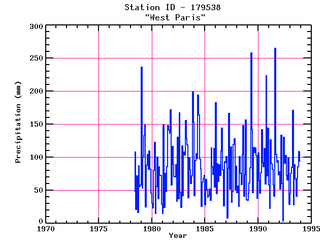
| Point Id | Year | PPT mm | |||||||||||
|---|---|---|---|---|---|---|---|---|---|---|---|---|---|
| Jan | Feb | Mar | Apr | May | Jun | Jul | Aug | Sep | Oct | Nov | Dec | ||
| 179538 | 1970 | ||||||||||||
| 179538 | 1971 | ||||||||||||
| 179538 | 1972 | ||||||||||||
| 179538 | 1973 | ||||||||||||
| 179538 | 1974 | ||||||||||||
| 179538 | 1975 | ||||||||||||
| 179538 | 1976 | ||||||||||||
| 179538 | 1977 | ||||||||||||
| 179538 | 1978 | 49 | 108 | 21 | 72 | 17 | 87 | 56 | 58 | ||||
| 179538 | 1979 | 236 | 53 | 101 | 133 | 149 | 25 | 88 | 104 | 82 | 110 | 82 | 46 |
| 179538 | 1980 | 31 | 23 | 80 | 123 | 15 | 56 | 101 | 37 | 86 | 73 | 73 | 29 |
| 179538 | 1981 | 15 | 149 | 24 | 76 | 48 | 86 | 148 | 142 | 136 | 172 | 58 | 117 |
| 179538 | 1982 | 90 | 71 | 70 | 89 | 34 | 130 | 38 | 167 | 47 | 25 | 117 | 42 |
| 179538 | 1983 | 108 | 103 | 155 | 128 | 119 | 39 | 100 | 81 | 60 | 72 | 199 | 153 |
| 179538 | 1984 | 42 | 95 | 106 | 98 | 194 | 165 | 97 | 82 | 25 | 63 | 68 | 73 |
| 179538 | 1985 | 28 | 66 | 51 | 40 | 42 | 52 | 35 | 114 | 86 | 74 | 114 | 55 |
| 179538 | 1986 | 183 | 45 | 91 | 64 | 89 | 72 | 110 | 144 | 81 | 26 | 94 | 92 |
| 179538 | 1987 | 101 | 8 | 83 | 166 | 52 | 116 | 32 | 48 | 120 | 128 | 51 | 86 |
| 179538 | 1988 | 46 | 57 | 26 | 101 | 76 | 59 | 104 | 148 | 41 | 73 | 157 | 36 |
| 179538 | 1989 | 35 | 46 | 62 | 85 | 258 | 142 | 46 | 115 | 107 | 114 | 102 | 38 |
| 179538 | 1990 | 106 | 65 | 46 | 77 | 142 | 92 | 86 | 113 | 60 | 224 | 72 | 144 |
| 179538 | 1991 | 58 | 23 | 126 | 90 | 82 | 58 | 41 | 265 | 104 | 92 | 95 | 73 |
| 179538 | 1992 | 78 | 52 | 133 | 60 | 4 | 131 | 91 | 103 | 73 | 66 | 99 | 29 |
| 179538 | 1993 | 46 | 76 | 85 | 171 | 28 | 89 | 67 | 41 | 69 | 86 | 109 | 94 |


