 |
 |
|
|
|
|
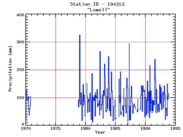
| Name: | LOWELL | Lattitude: | 42.65 |
|---|---|---|---|
| Station ID: | 194313 | Longitude: | -71.32 |
| Data Type: | Precipitation (mm) | Elevation: | 33.5 (m) |
| Data Source: | NCDC | Beginning Year: | 1948 |
| State / Province: | MA | Ending Year: | Present |
| Other Close Sites | ||
|---|---|---|
| Data Type | PointID | Name |
| Air Temperature (C) | 194313 | LOWELL |
| Stream Discharge (cms) | 01099500 | Concord R Below R Meadow Brook, At Lowell, Ma |
| Stream Discharge (cms) | 01100000 | Merrimack River Bl Concord River At Lowell, Ma |
| Snowfall (mm) | 194313 | LOWELL |
| Download | |
|---|---|
| Site Descriptor Information | Site Time Series Data |
| Point Id | Year | PPT mm | |||||||||||
|---|---|---|---|---|---|---|---|---|---|---|---|---|---|
| Jan | Feb | Mar | Apr | May | Jun | Jul | Aug | Sep | Oct | Nov | Dec | ||
| 194313 | 1970 | 23 | 126 | 96 | 92 | 93 | 104 | 56 | 37 | 59 | 72 | 103 | |
| 194313 | 1971 | ||||||||||||
| 194313 | 1972 | ||||||||||||
| 194313 | 1973 | ||||||||||||
| 194313 | 1974 | ||||||||||||
| 194313 | 1975 | ||||||||||||
| 194313 | 1976 | ||||||||||||
| 194313 | 1977 | ||||||||||||
| 194313 | 1978 | 93 | 66 | 89 | |||||||||
| 194313 | 1979 | 325 | 80 | 75 | 117 | 103 | 18 | 92 | 147 | 72 | 110 | 86 | 33 |
| 194313 | 1980 | 151 | 105 | 47 | 85 | 95 | 49 | 50 | 116 | 91 | 22 | ||
| 194313 | 1981 | 21 | 186 | 12 | 102 | 95 | 89 | 108 | 33 | 118 | 104 | 98 | 129 |
| 194313 | 1982 | 66 | 77 | 73 | 90 | 38 | 266 | 99 | 54 | 74 | 76 | 109 | 25 |
| 194313 | 1983 | 126 | 108 | 221 | 176 | 104 | 49 | 54 | 133 | 61 | 102 | 248 | 154 |
| 194313 | 1984 | 53 | 98 | 35 | 114 | 192 | 123 | 95 | 17 | 20 | 68 | 68 | 91 |
| 194313 | 1985 | 23 | 26 | 33 | 166 | 107 | 82 | 192 | 38 | ||||
| 194313 | 1986 | 49 | 56 | 71 | 32 | 132 | 98 | 71 | 45 | 140 | 170 | ||
| 194313 | 1987 | 136 | 292 | 19 | 69 | 20 | 102 | 141 | 84 | 73 | 43 | ||
| 194313 | 1988 | 69 | 77 | 78 | 69 | 61 | 57 | 49 | 95 | ||||
| 194313 | 1989 | 56 | 60 | 109 | 143 | 134 | 51 | 142 | 122 | 123 | 127 | 30 | |
| 194313 | 1990 | 100 | 101 | 38 | 90 | 160 | 45 | 90 | 122 | 28 | 216 | 53 | 125 |
| 194313 | 1991 | 80 | 46 | 92 | 53 | 89 | 74 | 76 | 238 | 163 | 46 | 130 | 77 |
| 194313 | 1992 | 56 | 48 | 77 | 59 | 49 | 146 | 80 | 136 | 74 | 57 | 110 | 119 |
| 194313 | 1993 | 63 | 90 | 142 | 109 | 21 | 57 | 62 | 34 | 150 | 93 | 105 | 116 |


