 |
 |
|
|
|
|
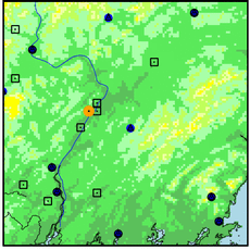
| Name: | WATERVILLE TRTMNT PL | Lattitude: | 44.55 |
|---|---|---|---|
| Station ID: | 179151 | Longitude: | -69.65 |
| Data Type: | Precipitation (mm) | Elevation: | 22.3 (m) |
| Data Source: | NCDC | Beginning Year: | 1958 |
| State / Province: | ME | Ending Year: | Present |
| Other Close Sites | ||
|---|---|---|
| Data Type | PointID | Name |
| Air Temperature (C) | 179151 | WATERVILLE TRTMNT PL |
| Stream Discharge (cms) | 01049205 | Kennebec River Near Waterville,Me |
| Snowfall (mm) | 179151 | WATERVILLE TRTMNT PL |
| Download | |
|---|---|
| Site Descriptor Information | Site Time Series Data |
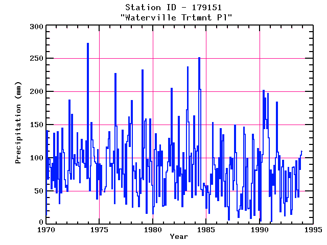
| Point Id | Year | PPT mm | |||||||||||
|---|---|---|---|---|---|---|---|---|---|---|---|---|---|
| Jan | Feb | Mar | Apr | May | Jun | Jul | Aug | Sep | Oct | Nov | Dec | ||
| 179151 | 1970 | 14 | 141 | 68 | 99 | 98 | 86 | 53 | 92 | 66 | 137 | 56 | 102 |
| 179151 | 1971 | 47 | 140 | 68 | 32 | 107 | 48 | 145 | 113 | 108 | 67 | 55 | 59 |
| 179151 | 1972 | 50 | 81 | 188 | 76 | 68 | 166 | 99 | 68 | 105 | 91 | 89 | 138 |
| 179151 | 1973 | 94 | 87 | 63 | 113 | 128 | 93 | 112 | 92 | 86 | 126 | 69 | 272 |
| 179151 | 1974 | 69 | 50 | 88 | 154 | 127 | 116 | 103 | 94 | 92 | 38 | 113 | 68 |
| 179151 | 1975 | 91 | 44 | 89 | 52 | 49 | 53 | 57 | 117 | 114 | 129 | 139 | |
| 179151 | 1976 | 87 | 92 | 54 | 92 | 110 | 32 | 227 | 148 | 77 | 113 | 67 | 84 |
| 179151 | 1977 | 83 | 55 | 142 | 76 | 41 | 121 | 30 | 125 | 134 | 162 | 117 | 152 |
| 179151 | 1978 | 186 | 26 | 88 | 80 | 69 | 92 | 48 | 43 | 27 | 83 | 46 | 70 |
| 179151 | 1979 | 233 | 68 | 115 | 156 | 158 | 16 | 98 | 87 | 63 | 158 | 95 | 59 |
| 179151 | 1980 | 16 | 26 | 113 | 137 | 32 | 88 | 110 | 42 | 120 | 88 | 110 | 27 |
| 179151 | 1981 | 28 | 69 | 29 | 79 | 81 | 94 | 130 | 88 | 120 | 205 | 79 | 123 |
| 179151 | 1982 | 82 | 39 | 62 | 88 | 37 | 163 | 73 | 85 | 75 | 26 | 108 | 45 |
| 179151 | 1983 | 82 | 51 | 173 | 237 | 154 | 64 | 103 | 107 | 40 | 90 | 164 | 115 |
| 179151 | 1984 | 44 | 110 | 118 | 58 | 251 | 203 | 53 | 52 | 43 | 62 | 58 | 55 |
| 179151 | 1985 | 24 | 58 | 48 | 16 | 45 | 75 | 60 | 153 | 100 | 90 | 83 | 41 |
| 179151 | 1986 | 84 | 36 | 100 | 69 | 144 | 42 | 126 | 135 | 65 | 26 | 76 | 84 |
| 179151 | 1987 | 27 | 7 | 89 | 101 | 83 | 100 | 52 | 66 | 149 | 108 | 61 | 20 |
| 179151 | 1988 | 11 | 23 | 28 | 46 | 23 | 57 | 147 | 136 | 21 | 87 | 100 | 24 |
| 179151 | 1989 | 25 | 37 | 9 | 62 | 136 | 128 | 13 | 82 | 82 | 89 | 115 | 21 |
| 179151 | 1990 | 110 | 5 | 93 | 105 | 202 | 144 | 190 | 158 | 144 | 198 | 131 | 42 |
| 179151 | 1991 | 82 | 5 | 76 | 59 | 89 | 46 | 100 | 184 | 109 | 82 | 103 | 19 |
| 179151 | 1992 | 40 | 86 | 96 | 32 | 12 | 80 | 34 | 40 | 86 | 70 | 78 | 15 |
| 179151 | 1993 | 22 | 86 | 87 | 75 | 41 | 96 | 52 | 41 | 100 | 83 | 104 | 110 |


