 |
 |
|
|
|
|
| Name: | Neponset River At Milton Village, Ma | Lattitude: | 42.250000 |
|---|---|---|---|
| Station ID: | 011055566 | Longitude: | -71.116661 |
| Data Type: | Stream Discharge (cms) | Elevation: | |
| Data Source: | USGS | Beginning Year: | |
| State / Province: | MA | Ending Year: |
| Other Close Sites | ||
|---|---|---|
| Data Type | PointID | Name |
| Air Temperature (C) | 190736 | MILTON BLUE HILL OBS |
| Precipitation (mm) | 190736 | MILTON BLUE HILL OBS |
| Snowfall (mm) | 190736 | MILTON BLUE HILL OBS |
| Download | |
|---|---|
| Site Descriptor Information | Site Time Series Data |
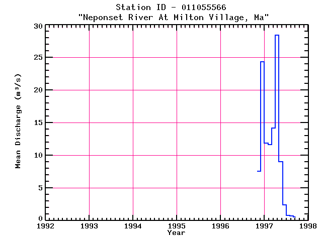
| Point Id | Year | Discharge m3/s | |||||||||||
|---|---|---|---|---|---|---|---|---|---|---|---|---|---|
| Jan | Feb | Mar | Apr | May | Jun | Jul | Aug | Sep | Oct | Nov | Dec | ||
| 011055566 | 1996 | 7.55 | 24.36 | ||||||||||
| 011055566 | 1997 | 11.89 | 11.62 | 14.18 | 28.38 | 9.01 | 2.44 | 0.83 | 0.74 | 0.55 | |||


