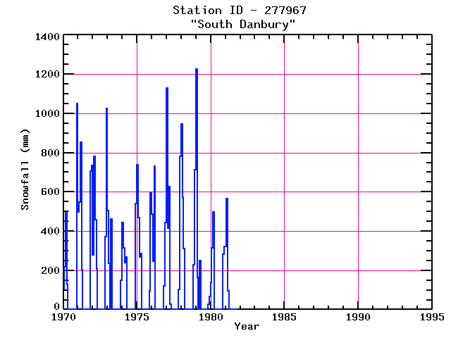
SOUTH DANBURY
| Name: | SOUTH DANBURY |
Lattitude: | 43.5 |
|---|
| Station ID: | 277967 |
Longitude: | -71.9 |
|---|
| Data Type: | Snowfall (mm) |
Elevation: | 284.1 (m) |
|---|
| Data Source: | NCDC |
Beginning Year: | 1966 |
|---|
| State / Province: | NH |
Ending Year: | 1981 |
|---|
| Other Close Sites |
|---|
| Data Type | PointID |
Name |
|---|
| Precipitation (mm) |
277967 |
SOUTH DANBURY |
Station Data File:
| Point Id | Year | Snowfall mm |
|---|
| Jan |
Feb |
Mar |
Apr |
May |
Jun |
Jul |
Aug |
Sep |
Oct |
Nov |
Dec |
| 277967 |
1970 | 107 |
218 |
493 |
127 |
|
|
|
|
|
|
|
1052 |
| 277967 |
1971 | 498 |
549 |
851 |
203 |
|
|
|
|
|
|
706 |
734 |
| 277967 |
1972 | 279 |
782 |
457 |
206 |
|
|
|
|
|
|
371 |
1026 |
| 277967 |
1973 | 506 |
236 |
|
462 |
|
|
|
|
|
|
|
147 |
| 277967 |
1974 | 444 |
315 |
239 |
269 |
|
|
|
|
|
|
|
538 |
| 277967 |
1975 | 737 |
467 |
269 |
284 |
|
|
|
|
|
|
96 |
594 |
| 277967 |
1976 | 488 |
246 |
732 |
|
|
|
|
|
|
|
122 |
444 |
| 277967 |
1977 | 1130 |
414 |
627 |
25 |
|
|
|
|
|
|
102 |
782 |
| 277967 |
1978 | 945 |
574 |
310 |
|
|
|
|
|
|
|
229 |
714 |
| 277967 |
1979 | 1224 |
163 |
|
249 |
|
|
|
|
|
|
25 |
66 |
| 277967 |
1980 | 137 |
312 |
498 |
|
|
|
|
|
|
|
282 |
320 |
| 277967 |
1981 | 320 |
564 |
94 |
|
|
|
|
|
|
|
|
|
| 277967 |
1982 |
|
|
|
|
|
|
|
|
|
|
|
|
| 277967 |
1983 |
|
|
|
|
|
|
|
|
|
|
|
|
| 277967 |
1984 |
|
|
|
|
|
|
|
|
|
|
|
|
| 277967 |
1985 |
|
|
|
|
|
|
|
|
|
|
|
|
| 277967 |
1986 |
|
|
|
|
|
|
|
|
|
|
|
|
| 277967 |
1987 |
|
|
|
|
|
|
|
|
|
|
|
|
| 277967 |
1988 |
|
|
|
|
|
|
|
|
|
|
|
|
| 277967 |
1989 |
|
|
|
|
|
|
|
|
|
|
|
|
| 277967 |
1990 |
|
|
|
|
|
|
|
|
|
|
|
|
| 277967 |
1991 |
|
|
|
|
|
|
|
|
|
|
|
|
| 277967 |
1992 |
|
|
|
|
|
|
|
|
|
|
|
|
| 277967 |
1993 |
|
|
|
|
|
|
|
|
|
|
|
|