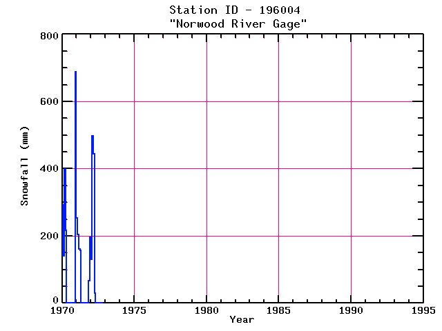
NORWOOD RIVER GAGE
| Name: | NORWOOD RIVER GAGE |
Lattitude: | 42.18 |
|---|
| Station ID: | 196004 |
Longitude: | -71.22 |
|---|
| Data Type: | Snowfall (mm) |
Elevation: | 42.7 (m) |
|---|
| Data Source: | NCDC |
Beginning Year: | 1962 |
|---|
| State / Province: | MA |
Ending Year: | Present |
|---|
| Other Close Sites |
|---|
| Data Type | PointID |
Name |
|---|
| Air Temperature (C) |
198755 |
WALPOLE |
| Air Temperature (C) |
198757 |
WALPOLE 2 |
| Precipitation (mm) |
196004 |
NORWOOD RIVER GAGE |
| Precipitation (mm) |
198755 |
WALPOLE |
| Precipitation (mm) |
198757 |
WALPOLE 2 |
| Snowfall (mm) |
198755 |
WALPOLE |
| Snowfall (mm) |
198757 |
WALPOLE 2 |
Station Data File:
| Point Id | Year | Snowfall mm |
|---|
| Jan |
Feb |
Mar |
Apr |
May |
Jun |
Jul |
Aug |
Sep |
Oct |
Nov |
Dec |
| 196004 |
1970 | 292 |
140 |
399 |
216 |
|
|
|
|
|
|
|
688 |
| 196004 |
1971 | 254 |
203 |
160 |
158 |
|
|
|
|
|
|
66 |
196 |
| 196004 |
1972 | 130 |
498 |
444 |
30 |
|
|
|
|
|
|
|
|
| 196004 |
1973 |
|
|
|
|
|
|
|
|
|
|
|
|
| 196004 |
1974 |
|
|
|
|
|
|
|
|
|
|
|
|
| 196004 |
1975 |
|
|
|
|
|
|
|
|
|
|
|
|
| 196004 |
1976 |
|
|
|
|
|
|
|
|
|
|
|
|
| 196004 |
1977 |
|
|
|
|
|
|
|
|
|
|
|
|
| 196004 |
1978 |
|
|
|
|
|
|
|
|
|
|
|
|
| 196004 |
1979 |
|
|
|
|
|
|
|
|
|
|
|
|
| 196004 |
1980 |
|
|
|
|
|
|
|
|
|
|
|
|
| 196004 |
1981 |
|
|
|
|
|
|
|
|
|
|
|
|
| 196004 |
1982 |
|
|
|
|
|
|
|
|
|
|
|
|
| 196004 |
1983 |
|
|
|
|
|
|
|
|
|
|
|
|
| 196004 |
1984 |
|
|
|
|
|
|
|
|
|
|
|
|
| 196004 |
1985 |
|
|
|
|
|
|
|
|
|
|
|
|
| 196004 |
1986 |
|
|
|
|
|
|
|
|
|
|
|
|
| 196004 |
1987 |
|
|
|
|
|
|
|
|
|
|
|
|
| 196004 |
1988 |
|
|
|
|
|
|
|
|
|
|
|
|
| 196004 |
1989 |
|
|
|
|
|
|
|
|
|
|
|
|
| 196004 |
1990 |
|
|
|
|
|
|
|
|
|
|
|
|
| 196004 |
1991 |
|
|
|
|
|
|
|
|
|
|
|
|
| 196004 |
1992 |
|
|
|
|
|
|
|
|
|
|
|
|
| 196004 |
1993 |
|
|
|
|
|
|
|
|
|
|
|
|