 |
 |
|
|
|
|
| Name: | PORTLAND INTL JETPRT | Lattitude: | 43.65 |
|---|---|---|---|
| Station ID: | 176905 | Longitude: | -70.32 |
| Data Type: | Snowfall (mm) | Elevation: | 13.7 (m) |
| Data Source: | NCDC | Beginning Year: | 1949 |
| State / Province: | ME | Ending Year: | Present |
| Other Close Sites | ||
|---|---|---|
| Data Type | PointID | Name |
| Air Temperature (C) | 176905 | PORTLAND INTL JETPRT |
| Stream Discharge (cms) | 01064118 | Presumpscot River At Westbrook, Me |
| Precipitation (mm) | 176905 | PORTLAND INTL JETPRT |
| Download | |
|---|---|
| Site Descriptor Information | Site Time Series Data |
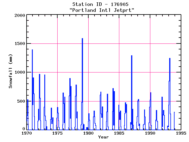
| Point Id | Year | Snowfall mm | |||||||||||
|---|---|---|---|---|---|---|---|---|---|---|---|---|---|
| Jan | Feb | Mar | Apr | May | Jun | Jul | Aug | Sep | Oct | Nov | Dec | ||
| 176905 | 1970 | 158 | 249 | 526 | 74 | 1392 | |||||||
| 176905 | 1971 | 437 | 904 | 627 | 234 | 158 | 361 | ||||||
| 176905 | 1972 | 178 | 965 | 551 | 160 | 396 | 958 | ||||||
| 176905 | 1973 | 244 | 168 | 13 | 58 | 183 | |||||||
| 176905 | 1974 | 381 | 109 | 158 | 211 | 81 | 208 | ||||||
| 176905 | 1975 | 391 | 295 | 160 | 43 | 91 | 643 | ||||||
| 176905 | 1976 | 460 | 124 | 572 | 38 | 592 | |||||||
| 176905 | 1977 | 894 | 201 | 757 | 36 | 48 | 587 | ||||||
| 176905 | 1978 | 780 | 208 | 318 | 20 | 91 | 480 | ||||||
| 176905 | 1979 | 1585 | 114 | 94 | 43 | 46 | |||||||
| 176905 | 1980 | 152 | 284 | 173 | 226 | 330 | |||||||
| 176905 | 1981 | 234 | 117 | 79 | 610 | ||||||||
| 176905 | 1982 | 658 | 279 | 216 | 404 | 15 | 145 | ||||||
| 176905 | 1983 | 315 | 622 | 53 | 320 | ||||||||
| 176905 | 1984 | 719 | 84 | 671 | 432 | ||||||||
| 176905 | 1985 | 307 | 183 | 333 | 61 | 79 | 284 | ||||||
| 176905 | 1986 | 472 | 305 | 444 | 132 | 102 | |||||||
| 176905 | 1987 | 1288 | 20 | 363 | 86 | 137 | 234 | ||||||
| 176905 | 1988 | 503 | 528 | 76 | 107 | 89 | |||||||
| 176905 | 1989 | 102 | 350 | 226 | 18 | 127 | 396 | ||||||
| 176905 | 1990 | 518 | 650 | 81 | 5 | 173 | |||||||
| 176905 | 1991 | 340 | 160 | 145 | 572 | ||||||||
| 176905 | 1992 | 61 | 262 | 340 | 254 | 71 | 53 | ||||||
| 176905 | 1993 | 434 | 851 | 1245 | 282 | 5 | 312 | ||||||


