 |
 |
|
|
|
|
| Name: | HOULTON | Lattitude: | 46.13 |
|---|---|---|---|
| Station ID: | 173897 | Longitude: | -67.83 |
| Data Type: | Snowfall (mm) | Elevation: | 125 (m) |
| Data Source: | NCDC | Beginning Year: | 1948 |
| State / Province: | ME | Ending Year: | 1985 |
| Other Close Sites | ||
|---|---|---|
| Data Type | PointID | Name |
| Air Temperature (C) | 173897 | HOULTON |
| Stream Discharge (cms) | 01018000 | Meduxnekeag River Near Houlton, Me |
| Precipitation (mm) | 173897 | HOULTON |
| Download | |
|---|---|
| Site Descriptor Information | Site Time Series Data |
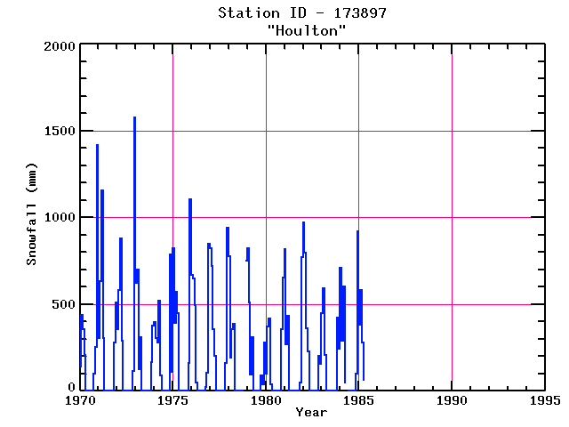
| Point Id | Year | Snowfall mm | |||||||||||
|---|---|---|---|---|---|---|---|---|---|---|---|---|---|
| Jan | Feb | Mar | Apr | May | Jun | Jul | Aug | Sep | Oct | Nov | Dec | ||
| 173897 | 1970 | 140 | 437 | 356 | 208 | 102 | 254 | 1420 | |||||
| 173897 | 1971 | 305 | 635 | 1156 | 305 | 279 | 508 | ||||||
| 173897 | 1972 | 356 | 584 | 881 | 292 | 117 | 1575 | ||||||
| 173897 | 1973 | 622 | 698 | 127 | 312 | 165 | 376 | ||||||
| 173897 | 1974 | 399 | 305 | 282 | 521 | 89 | 787 | 109 | |||||
| 173897 | 1975 | 823 | 394 | 572 | 450 | 160 | 1105 | ||||||
| 173897 | 1976 | 668 | 648 | 495 | 51 | 25 | 107 | 851 | |||||
| 173897 | 1977 | 826 | 721 | 356 | 203 | 163 | 940 | ||||||
| 173897 | 1978 | 777 | 190 | 356 | 389 | 752 | |||||||
| 173897 | 1979 | 826 | 508 | 96 | 312 | 89 | 38 | 279 | |||||
| 173897 | 1980 | 102 | 373 | 419 | 38 | 356 | 655 | ||||||
| 173897 | 1981 | 820 | 267 | 432 | 51 | 772 | |||||||
| 173897 | 1982 | 973 | 795 | 363 | 229 | 203 | 155 | ||||||
| 173897 | 1983 | 447 | 592 | 208 | 424 | 241 | |||||||
| 173897 | 1984 | 709 | 292 | 602 | 51 | 102 | 920 | ||||||
| 173897 | 1985 | 381 | 582 | 279 | 64 | ||||||||
| 173897 | 1986 | ||||||||||||
| 173897 | 1987 | ||||||||||||
| 173897 | 1988 | ||||||||||||
| 173897 | 1989 | ||||||||||||
| 173897 | 1990 | ||||||||||||
| 173897 | 1991 | ||||||||||||
| 173897 | 1992 | ||||||||||||
| 173897 | 1993 | ||||||||||||


