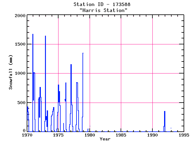
HARRIS STATION
| Name: | HARRIS STATION |
Lattitude: | 45.47 |
|---|
| Station ID: | 173588 |
Longitude: | -69.87 |
|---|
| Data Type: | Snowfall (mm) |
Elevation: | 253 (m) |
|---|
| Data Source: | NCDC |
Beginning Year: | 1969 |
|---|
| State / Province: | ME |
Ending Year: | Present |
|---|
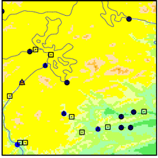
| Other Close Sites |
|---|
| Data Type | PointID |
Name |
|---|
| Precipitation (mm) |
173588 |
HARRIS STATION |
Station Data File:
| Point Id | Year | Snowfall mm |
|---|
| Jan |
Feb |
Mar |
Apr |
May |
Jun |
Jul |
Aug |
Sep |
Oct |
Nov |
Dec |
| 173588 |
1970 | 203 |
429 |
343 |
208 |
|
|
|
|
|
|
|
1669 |
| 173588 |
1971 | 538 |
1014 |
1006 |
211 |
|
|
|
|
|
|
564 |
587 |
| 173588 |
1972 | 249 |
760 |
594 |
521 |
|
|
|
|
|
|
183 |
1641 |
| 173588 |
1973 | 208 |
262 |
89 |
363 |
|
|
|
|
|
|
117 |
267 |
| 173588 |
1974 | 290 |
350 |
381 |
417 |
25 |
|
|
|
|
51 |
282 |
335 |
| 173588 |
1975 | 803 |
508 |
691 |
450 |
|
|
|
|
|
|
145 |
|
| 173588 |
1976 | 559 |
526 |
838 |
38 |
|
|
|
|
|
86 |
127 |
310 |
| 173588 |
1977 | 1151 |
498 |
460 |
96 |
|
|
|
|
|
|
122 |
846 |
| 173588 |
1978 | 838 |
589 |
361 |
51 |
|
|
|
|
|
|
254 |
1349 |
| 173588 |
1979 |
|
|
|
|
|
|
|
|
|
51 |
|
|
| 173588 |
1980 | 102 |
|
|
|
|
|
|
|
|
|
|
|
| 173588 |
1981 |
|
|
|
|
|
|
|
|
|
|
|
|
| 173588 |
1982 |
|
|
|
|
|
|
|
|
|
|
|
|
| 173588 |
1983 |
|
|
|
|
|
|
|
|
|
|
|
|
| 173588 |
1984 |
|
|
|
|
|
|
|
|
|
|
|
|
| 173588 |
1985 |
|
|
|
|
|
|
|
|
|
|
|
|
| 173588 |
1986 |
|
|
|
|
|
|
|
|
|
|
|
|
| 173588 |
1987 |
|
|
|
|
|
|
|
|
|
|
|
|
| 173588 |
1988 |
|
|
|
|
|
|
|
|
|
|
|
|
| 173588 |
1989 |
|
|
|
|
|
|
|
|
|
|
|
|
| 173588 |
1990 |
|
|
|
|
|
|
|
|
|
|
|
|
| 173588 |
1991 |
|
|
|
|
|
|
|
|
|
|
96 |
350 |
| 173588 |
1992 |
|
|
|
|
|
|
|
|
|
|
|
64 |
| 173588 |
1993 |
|
|
|
|
|
|
|
|
|
|
|
|