 |
 |
|
|
|
|
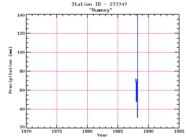
| Name: | RUMNEY | Lattitude: | 43.8 |
|---|---|---|---|
| Station ID: | 277747 | Longitude: | -71.82 |
| Data Type: | Precipitation (mm) | Elevation: | 155.4 (m) |
| Data Source: | NCDC | Beginning Year: | 1987 |
| State / Province: | NH | Ending Year: | 1988 |
| Other Close Sites | ||
|---|---|---|
| Data Type | PointID | Name |
| Air Temperature (C) | 279474 | WEST RUMNEY |
| Stream Discharge (cms) | 01076000 | Baker River Near Rumney, Nh |
| Precipitation (mm) | 279474 | WEST RUMNEY |
| Snowfall (mm) | 277747 | RUMNEY |
| Snowfall (mm) | 279474 | WEST RUMNEY |
| Download | |
|---|---|
| Site Descriptor Information | Site Time Series Data |
| Point Id | Year | PPT mm | |||||||||||
|---|---|---|---|---|---|---|---|---|---|---|---|---|---|
| Jan | Feb | Mar | Apr | May | Jun | Jul | Aug | Sep | Oct | Nov | Dec | ||
| 277747 | 1970 | ||||||||||||
| 277747 | 1971 | ||||||||||||
| 277747 | 1972 | ||||||||||||
| 277747 | 1973 | ||||||||||||
| 277747 | 1974 | ||||||||||||
| 277747 | 1975 | ||||||||||||
| 277747 | 1976 | ||||||||||||
| 277747 | 1977 | ||||||||||||
| 277747 | 1978 | ||||||||||||
| 277747 | 1979 | ||||||||||||
| 277747 | 1980 | ||||||||||||
| 277747 | 1981 | ||||||||||||
| 277747 | 1982 | ||||||||||||
| 277747 | 1983 | ||||||||||||
| 277747 | 1984 | ||||||||||||
| 277747 | 1985 | ||||||||||||
| 277747 | 1986 | ||||||||||||
| 277747 | 1987 | 72 | 69 | ||||||||||
| 277747 | 1988 | 48 | 71 | 31 | 140 | ||||||||
| 277747 | 1989 | ||||||||||||
| 277747 | 1990 | ||||||||||||
| 277747 | 1991 | ||||||||||||
| 277747 | 1992 | ||||||||||||
| 277747 | 1993 | ||||||||||||


