 |
 |
|
|
|
|
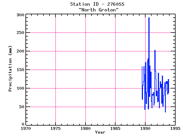
| Name: | NORTH GROTON | Lattitude: | 43.77 |
|---|---|---|---|
| Station ID: | 276055 | Longitude: | -71.87 |
| Data Type: | Precipitation (mm) | Elevation: | 393.2 (m) |
| Data Source: | NCDC | Beginning Year: | 1989 |
| State / Province: | NH | Ending Year: | Present |
| Other Close Sites | ||
|---|---|---|
| Data Type | PointID | Name |
| Air Temperature (C) | 279474 | WEST RUMNEY |
| Stream Discharge (cms) | 01076000 | Baker River Near Rumney, Nh |
| Precipitation (mm) | 279474 | WEST RUMNEY |
| Snowfall (mm) | 276055 | NORTH GROTON |
| Snowfall (mm) | 279474 | WEST RUMNEY |
| Download | |
|---|---|
| Site Descriptor Information | Site Time Series Data |
| Point Id | Year | PPT mm | |||||||||||
|---|---|---|---|---|---|---|---|---|---|---|---|---|---|
| Jan | Feb | Mar | Apr | May | Jun | Jul | Aug | Sep | Oct | Nov | Dec | ||
| 276055 | 1970 | ||||||||||||
| 276055 | 1971 | ||||||||||||
| 276055 | 1972 | ||||||||||||
| 276055 | 1973 | ||||||||||||
| 276055 | 1974 | ||||||||||||
| 276055 | 1975 | ||||||||||||
| 276055 | 1976 | ||||||||||||
| 276055 | 1977 | ||||||||||||
| 276055 | 1978 | ||||||||||||
| 276055 | 1979 | ||||||||||||
| 276055 | 1980 | ||||||||||||
| 276055 | 1981 | ||||||||||||
| 276055 | 1982 | ||||||||||||
| 276055 | 1983 | ||||||||||||
| 276055 | 1984 | ||||||||||||
| 276055 | 1985 | ||||||||||||
| 276055 | 1986 | ||||||||||||
| 276055 | 1987 | ||||||||||||
| 276055 | 1988 | ||||||||||||
| 276055 | 1989 | 158 | 70 | 107 | 118 | 158 | 137 | 43 | |||||
| 276055 | 1990 | 170 | 88 | 59 | 90 | 174 | 179 | 44 | 290 | 78 | 160 | 100 | 144 |
| 276055 | 1991 | 64 | 47 | 84 | 81 | 89 | 54 | 61 | 203 | 147 | 125 | 80 | 93 |
| 276055 | 1992 | 72 | 64 | 141 | 66 | 47 | 99 | 118 | 103 | 111 | 60 | 133 | 52 |
| 276055 | 1993 | 68 | 81 | 103 | 116 | 36 | 94 | 119 | 113 | 118 | 84 | 124 | 89 |


