 |
 |
|
|
|
|
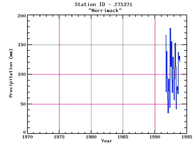
| Name: | MERRIMACK | Lattitude: | 42.85 |
|---|---|---|---|
| Station ID: | 275371 | Longitude: | -71.53 |
| Data Type: | Precipitation (mm) | Elevation: | 73.2 (m) |
| Data Source: | NCDC | Beginning Year: | 1991 |
| State / Province: | NH | Ending Year: | Present |
| Other Close Sites | ||
|---|---|---|
| Data Type | PointID | Name |
| Stream Discharge (cms) | 01094000 | Souhegan River At Merrimack, Nh |
| Snowfall (mm) | 275371 | MERRIMACK |
| Download | |
|---|---|
| Site Descriptor Information | Site Time Series Data |
| Point Id | Year | PPT mm | |||||||||||
|---|---|---|---|---|---|---|---|---|---|---|---|---|---|
| Jan | Feb | Mar | Apr | May | Jun | Jul | Aug | Sep | Oct | Nov | Dec | ||
| 275371 | 1970 | ||||||||||||
| 275371 | 1971 | ||||||||||||
| 275371 | 1972 | ||||||||||||
| 275371 | 1973 | ||||||||||||
| 275371 | 1974 | ||||||||||||
| 275371 | 1975 | ||||||||||||
| 275371 | 1976 | ||||||||||||
| 275371 | 1977 | ||||||||||||
| 275371 | 1978 | ||||||||||||
| 275371 | 1979 | ||||||||||||
| 275371 | 1980 | ||||||||||||
| 275371 | 1981 | ||||||||||||
| 275371 | 1982 | ||||||||||||
| 275371 | 1983 | ||||||||||||
| 275371 | 1984 | ||||||||||||
| 275371 | 1985 | ||||||||||||
| 275371 | 1986 | ||||||||||||
| 275371 | 1987 | ||||||||||||
| 275371 | 1988 | ||||||||||||
| 275371 | 1989 | ||||||||||||
| 275371 | 1990 | ||||||||||||
| 275371 | 1991 | 165 | 70 | 139 | 95 | ||||||||
| 275371 | 1992 | 58 | 35 | 92 | 72 | 44 | 178 | 114 | 155 | 89 | 69 | 129 | 110 |
| 275371 | 1993 | 57 | 93 | 153 | 113 | 42 | 74 | 79 | 68 | 137 | 126 | 131 | 122 |


