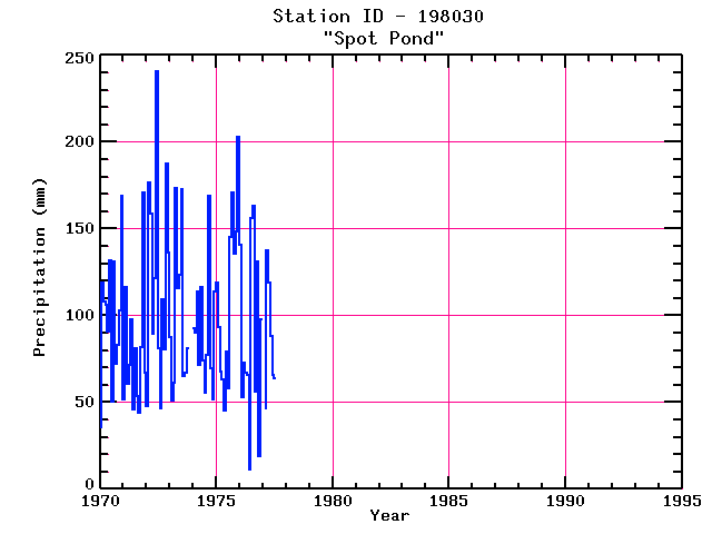
SPOT POND
| Name: | SPOT POND |
Lattitude: | 42.45 |
|---|
| Station ID: | 198030 |
Longitude: | -71.08 |
|---|
| Data Type: | Precipitation (mm) |
Elevation: | 52.1 (m) |
|---|
| Data Source: | NCDC |
Beginning Year: | 1948 |
|---|
| State / Province: | MA |
Ending Year: | 1977 |
|---|
| Other Close Sites |
|---|
| Data Type | PointID |
Name |
|---|
| Snowfall (mm) |
198030 |
SPOT POND |
Station Data File:
| Point Id | Year | PPT mm |
|---|
| Jan |
Feb |
Mar |
Apr |
May |
Jun |
Jul |
Aug |
Sep |
Oct |
Nov |
Dec |
| 198030 |
1970 | 36 |
119 |
108 |
106 |
91 |
132 |
50 |
131 |
72 |
83 |
103 |
169 |
| 198030 |
1971 | 52 |
117 |
60 |
72 |
98 |
46 |
81 |
54 |
44 |
82 |
171 |
67 |
| 198030 |
1972 | 48 |
177 |
158 |
90 |
121 |
241 |
81 |
46 |
110 |
80 |
188 |
136 |
| 198030 |
1973 | 87 |
51 |
61 |
174 |
116 |
123 |
173 |
65 |
67 |
81 |
|
|
| 198030 |
1974 | 93 |
90 |
114 |
72 |
116 |
74 |
55 |
78 |
169 |
70 |
52 |
114 |
| 198030 |
1975 | 119 |
93 |
68 |
63 |
46 |
79 |
58 |
145 |
171 |
136 |
148 |
203 |
| 198030 |
1976 | 141 |
53 |
73 |
67 |
66 |
11 |
156 |
163 |
56 |
131 |
19 |
98 |
| 198030 |
1977 |
|
47 |
137 |
119 |
88 |
66 |
64 |
|
|
|
|
|
| 198030 |
1978 |
|
|
|
|
|
|
|
|
|
|
|
|
| 198030 |
1979 |
|
|
|
|
|
|
|
|
|
|
|
|
| 198030 |
1980 |
|
|
|
|
|
|
|
|
|
|
|
|
| 198030 |
1981 |
|
|
|
|
|
|
|
|
|
|
|
|
| 198030 |
1982 |
|
|
|
|
|
|
|
|
|
|
|
|
| 198030 |
1983 |
|
|
|
|
|
|
|
|
|
|
|
|
| 198030 |
1984 |
|
|
|
|
|
|
|
|
|
|
|
|
| 198030 |
1985 |
|
|
|
|
|
|
|
|
|
|
|
|
| 198030 |
1986 |
|
|
|
|
|
|
|
|
|
|
|
|
| 198030 |
1987 |
|
|
|
|
|
|
|
|
|
|
|
|
| 198030 |
1988 |
|
|
|
|
|
|
|
|
|
|
|
|
| 198030 |
1989 |
|
|
|
|
|
|
|
|
|
|
|
|
| 198030 |
1990 |
|
|
|
|
|
|
|
|
|
|
|
|
| 198030 |
1991 |
|
|
|
|
|
|
|
|
|
|
|
|
| 198030 |
1992 |
|
|
|
|
|
|
|
|
|
|
|
|
| 198030 |
1993 |
|
|
|
|
|
|
|
|
|
|
|
|