 |
 |
|
|
|
|
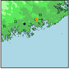
| Name: | MACHIAS | Lattitude: | 44.72 |
|---|---|---|---|
| Station ID: | 174878 | Longitude: | -67.47 |
| Data Type: | Precipitation (mm) | Elevation: | 6.1 (m) |
| Data Source: | NCDC | Beginning Year: | 1955 |
| State / Province: | ME | Ending Year: | Present |
| Other Close Sites | ||
|---|---|---|
| Data Type | PointID | Name |
| Air Temperature (C) | 174878 | MACHIAS |
| Stream Discharge (cms) | 01021500 | Machias River At Whitneyville, Me |
| Snowfall (mm) | 174878 | MACHIAS |
| Download | |
|---|---|
| Site Descriptor Information | Site Time Series Data |
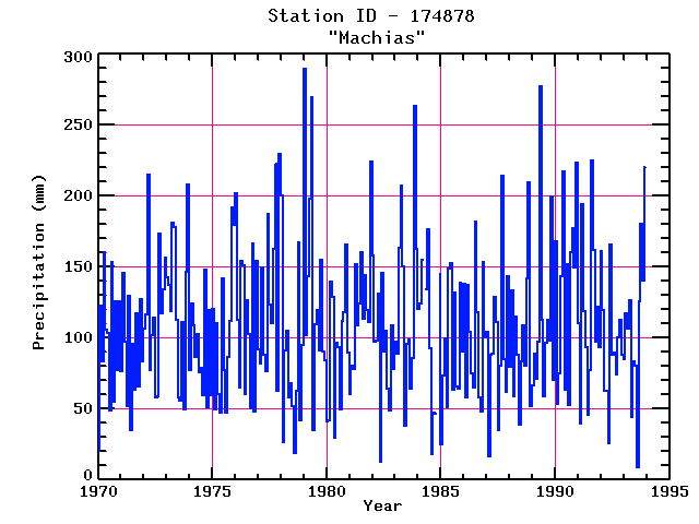
| Point Id | Year | PPT mm | |||||||||||
|---|---|---|---|---|---|---|---|---|---|---|---|---|---|
| Jan | Feb | Mar | Apr | May | Jun | Jul | Aug | Sep | Oct | Nov | Dec | ||
| 174878 | 1970 | 20 | 123 | 83 | 160 | 106 | 103 | 49 | 153 | 55 | 126 | 78 | 126 |
| 174878 | 1971 | 76 | 146 | 98 | 52 | 130 | 35 | 96 | 64 | 117 | 66 | 128 | 83 |
| 174878 | 1972 | 107 | 117 | 215 | 77 | 102 | 114 | 58 | 59 | 174 | 118 | 134 | 156 |
| 174878 | 1973 | 143 | 137 | 119 | 181 | 178 | 113 | 58 | 56 | 112 | 49 | 146 | 208 |
| 174878 | 1974 | 78 | 124 | 108 | 87 | 103 | 76 | 78 | 60 | 148 | 51 | 120 | 60 |
| 174878 | 1975 | 121 | 50 | 110 | 60 | 48 | 142 | 78 | 48 | 87 | 112 | 192 | 180 |
| 174878 | 1976 | 202 | 112 | 65 | 154 | 151 | 60 | 126 | 103 | 50 | 167 | 48 | 154 |
| 174878 | 1977 | 92 | 82 | 150 | 88 | 76 | 188 | 124 | 111 | 163 | 223 | 63 | 230 |
| 174878 | 1978 | 200 | 27 | 91 | 105 | 58 | 68 | 52 | 19 | 62 | 167 | 42 | 95 |
| 174878 | 1979 | 290 | 102 | 144 | 198 | 270 | 35 | 110 | 120 | 91 | 155 | 90 | 84 |
| 174878 | 1980 | 41 | 42 | 139 | 129 | 30 | 97 | 94 | 50 | 112 | 118 | 165 | 90 |
| 174878 | 1981 | 60 | 80 | 78 | 152 | 109 | 124 | 160 | 114 | 144 | 120 | 112 | 224 |
| 174878 | 1982 | 158 | 98 | 98 | 131 | 13 | 146 | 91 | 105 | 64 | 48 | 109 | 78 |
| 174878 | 1983 | 97 | 89 | 164 | 208 | 150 | 38 | 96 | 99 | 64 | 86 | 263 | 163 |
| 174878 | 1984 | 120 | 124 | 155 | 134 | 176 | 93 | 18 | 47 | 47 | 145 | ||
| 174878 | 1985 | 25 | 73 | 100 | 51 | 149 | 153 | 64 | 132 | 66 | 64 | 139 | 90 |
| 174878 | 1986 | 138 | 58 | 137 | 104 | 75 | 65 | 182 | 118 | 58 | 48 | 153 | 100 |
| 174878 | 1987 | 104 | 16 | 88 | 89 | 129 | 112 | 35 | 80 | 214 | 85 | 62 | 144 |
| 174878 | 1988 | 80 | 134 | 59 | 115 | 88 | 39 | 83 | 109 | 80 | 142 | 210 | 52 |
| 174878 | 1989 | 66 | 89 | 71 | 97 | 277 | 113 | 59 | 96 | 113 | 98 | 199 | 71 |
| 174878 | 1990 | 168 | 54 | 75 | 143 | 217 | 63 | 152 | 53 | 160 | 177 | 150 | 223 |
| 174878 | 1991 | 111 | 39 | 195 | 119 | 93 | 46 | 77 | 225 | 162 | 97 | 122 | 94 |
| 174878 | 1992 | 162 | 120 | 63 | 63 | 25 | 166 | 88 | 90 | 74 | 101 | 112 | 88 |
| 174878 | 1993 | 85 | 117 | 106 | 126 | 44 | 84 | 80 | 9 | 126 | 181 | 141 | 221 |


