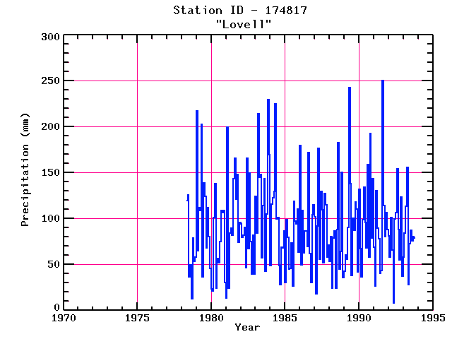
LOVELL
| Name: | LOVELL |
Lattitude: | 44.12 |
|---|
| Station ID: | 174817 |
Longitude: | -70.9 |
|---|
| Data Type: | Precipitation (mm) |
Elevation: | 149.4 (m) |
|---|
| Data Source: | NCDC |
Beginning Year: | 1973 |
|---|
| State / Province: | ME |
Ending Year: | 1993 |
|---|
| Other Close Sites |
|---|
| Data Type | PointID |
Name |
|---|
| Air Temperature (C) |
174817 |
LOVELL |
| Snowfall (mm) |
174817 |
LOVELL |
Station Data File:
| Point Id | Year | PPT mm |
|---|
| Jan |
Feb |
Mar |
Apr |
May |
Jun |
Jul |
Aug |
Sep |
Oct |
Nov |
Dec |
| 174817 |
1970 |
|
|
|
|
|
|
|
|
|
|
|
|
| 174817 |
1971 |
|
|
|
|
|
|
|
|
|
|
|
|
| 174817 |
1972 |
|
|
|
|
|
|
|
|
|
|
|
|
| 174817 |
1973 |
|
|
|
|
|
|
|
|
|
|
|
|
| 174817 |
1974 |
|
|
|
|
|
|
|
|
|
|
|
|
| 174817 |
1975 |
|
|
|
|
|
|
|
|
|
|
|
|
| 174817 |
1976 |
|
|
|
|
|
|
|
|
|
|
|
|
| 174817 |
1977 |
|
|
|
|
|
|
|
|
|
|
|
|
| 174817 |
1978 |
|
|
|
|
119 |
126 |
36 |
49 |
13 |
79 |
54 |
58 |
| 174817 |
1979 | 217 |
65 |
112 |
108 |
203 |
37 |
139 |
124 |
68 |
112 |
80 |
46 |
| 174817 |
1980 | 23 |
21 |
101 |
138 |
24 |
57 |
52 |
75 |
108 |
107 |
109 |
30 |
| 174817 |
1981 | 14 |
200 |
24 |
85 |
90 |
82 |
143 |
165 |
121 |
148 |
74 |
96 |
| 174817 |
1982 | 94 |
80 |
82 |
90 |
47 |
166 |
67 |
150 |
75 |
40 |
82 |
40 |
| 174817 |
1983 | 124 |
85 |
215 |
145 |
148 |
57 |
115 |
143 |
43 |
105 |
230 |
169 |
| 174817 |
1984 | 48 |
116 |
123 |
130 |
225 |
100 |
101 |
48 |
28 |
69 |
68 |
86 |
| 174817 |
1985 | 30 |
99 |
80 |
45 |
46 |
73 |
26 |
119 |
97 |
94 |
110 |
64 |
| 174817 |
1986 | 180 |
50 |
108 |
63 |
87 |
86 |
70 |
172 |
62 |
30 |
105 |
115 |
| 174817 |
1987 | 102 |
18 |
92 |
177 |
56 |
129 |
110 |
52 |
128 |
115 |
58 |
71 |
| 174817 |
1988 | 53 |
80 |
24 |
79 |
87 |
24 |
88 |
183 |
45 |
64 |
150 |
36 |
| 174817 |
1989 | 43 |
61 |
56 |
90 |
243 |
138 |
38 |
100 |
87 |
118 |
110 |
42 |
| 174817 |
1990 | 132 |
68 |
37 |
99 |
134 |
96 |
68 |
158 |
58 |
193 |
79 |
144 |
| 174817 |
1991 | 69 |
26 |
130 |
89 |
78 |
40 |
43 |
251 |
114 |
80 |
106 |
88 |
| 174817 |
1992 | 82 |
58 |
101 |
66 |
8 |
100 |
107 |
154 |
88 |
55 |
123 |
37 |
| 174817 |
1993 | 58 |
84 |
114 |
155 |
28 |
72 |
87 |
76 |
80 |
78 |
|
|