 |
 |
|
|
|
|
| Name: | LONG FALLS DAM | Lattitude: | 45.22 |
|---|---|---|---|
| Station ID: | 174781 | Longitude: | -70.2 |
| Data Type: | Precipitation (mm) | Elevation: | 353.6 (m) |
| Data Source: | NCDC | Beginning Year: | 1953 |
| State / Province: | ME | Ending Year: | Present |
| Other Close Sites | ||
|---|---|---|
| Data Type | PointID | Name |
| Air Temperature (C) | 174781 | LONG FALLS DAM |
| Stream Discharge (cms) | 01043500 | Dead River Near Dead River, Me |
| Snowfall (mm) | 174781 | LONG FALLS DAM |
| Download | |
|---|---|
| Site Descriptor Information | Site Time Series Data |
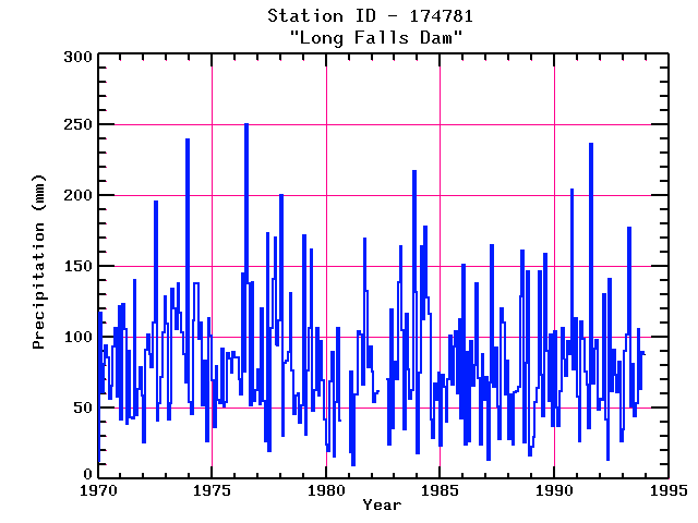
| Point Id | Year | PPT mm | |||||||||||
|---|---|---|---|---|---|---|---|---|---|---|---|---|---|
| Jan | Feb | Mar | Apr | May | Jun | Jul | Aug | Sep | Oct | Nov | Dec | ||
| 174781 | 1970 | 13 | 117 | 61 | 81 | 94 | 86 | 57 | 66 | 94 | 106 | 58 | 122 |
| 174781 | 1971 | 42 | 124 | 106 | 39 | 91 | 44 | 42 | 140 | 45 | 64 | 79 | 59 |
| 174781 | 1972 | 26 | 91 | 102 | 88 | 79 | 110 | 196 | 41 | 53 | 72 | 103 | 128 |
| 174781 | 1973 | 110 | 42 | 54 | 134 | 120 | 106 | 138 | 118 | 103 | 88 | 68 | 239 |
| 174781 | 1974 | 55 | 46 | 112 | 138 | 138 | 99 | 110 | 52 | 83 | 26 | 113 | 101 |
| 174781 | 1975 | 70 | 37 | 80 | 56 | 53 | 92 | 51 | 55 | 89 | 85 | 75 | 90 |
| 174781 | 1976 | 86 | 86 | 70 | 60 | 145 | 76 | 250 | 138 | 52 | 139 | 55 | 62 |
| 174781 | 1977 | 77 | 53 | 121 | 55 | 27 | 173 | 20 | 107 | 142 | 170 | 94 | 112 |
| 174781 | 1978 | 201 | 31 | 82 | 83 | 90 | 131 | 76 | 46 | 59 | 61 | 40 | 52 |
| 174781 | 1979 | 172 | 31 | 77 | 106 | 162 | 48 | 63 | 107 | 59 | 98 | 69 | 42 |
| 174781 | 1980 | 24 | 19 | 69 | 90 | 16 | 54 | 106 | 41 | ||||
| 174781 | 1981 | 19 | 76 | 10 | 60 | 59 | 104 | 102 | 66 | 169 | 133 | 79 | 93 |
| 174781 | 1982 | 75 | 54 | 61 | 62 | 70 | 25 | 120 | 36 | ||||
| 174781 | 1983 | 83 | 71 | 139 | 164 | 105 | 35 | 117 | 77 | 57 | 63 | 217 | 132 |
| 174781 | 1984 | 18 | 75 | 165 | 113 | 178 | 128 | 116 | 42 | 29 | 67 | 56 | 75 |
| 174781 | 1985 | 24 | 73 | 65 | 40 | 70 | 101 | 66 | 94 | 105 | 60 | 113 | 43 |
| 174781 | 1986 | 151 | 24 | 90 | 26 | 97 | 66 | 80 | 138 | 71 | 24 | 88 | 56 |
| 174781 | 1987 | 72 | 14 | 68 | 165 | 65 | 92 | 51 | 28 | 120 | 111 | 60 | 84 |
| 174781 | 1988 | 28 | 59 | 24 | 61 | 62 | 65 | 129 | 161 | 25 | 82 | 147 | 16 |
| 174781 | 1989 | 23 | 30 | 55 | 64 | 146 | 73 | 44 | 158 | 91 | 55 | 102 | 38 |
| 174781 | 1990 | 104 | 50 | 37 | 62 | 106 | 84 | 73 | 97 | 88 | 204 | 77 | 113 |
| 174781 | 1991 | 58 | 26 | 111 | 99 | 76 | 66 | 36 | 237 | 68 | 92 | 98 | 49 |
| 174781 | 1992 | 56 | 56 | 131 | 42 | 14 | 141 | 62 | 91 | 73 | 61 | 83 | 27 |
| 174781 | 1993 | 35 | 90 | 102 | 177 | 51 | 81 | 44 | 54 | 105 | 64 | 89 | 88 |


