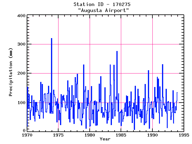
AUGUSTA AIRPORT
| Name: | AUGUSTA AIRPORT |
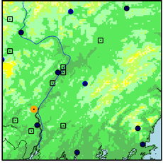
Lattitude: | 44.32 |
|---|
| Station ID: | 170275 |
Longitude: | -69.8 |
|---|
| Data Type: | Precipitation (mm) |
Elevation: | 106.7 (m) |
|---|
| Data Source: | NCDC |
Beginning Year: | 1948 |
|---|
| State / Province: | ME |
Ending Year: | Present |
|---|
| Other Close Sites |
|---|
| Data Type | PointID |
Name |
|---|
| Air Temperature (C) |
170275 |
AUGUSTA AIRPORT |
| Snowfall (mm) |
170275 |
AUGUSTA AIRPORT |
Station Data File:
| Point Id | Year | PPT mm |
|---|
| Jan |
Feb |
Mar |
Apr |
May |
Jun |
Jul |
Aug |
Sep |
Oct |
Nov |
Dec |
| 170275 |
1970 | 19 |
153 |
80 |
104 |
127 |
81 |
42 |
68 |
74 |
124 |
86 |
85 |
| 170275 |
1971 | 55 |
108 |
47 |
36 |
101 |
68 |
101 |
91 |
76 |
71 |
56 |
57 |
| 170275 |
1972 | 46 |
107 |
169 |
69 |
80 |
162 |
67 |
47 |
104 |
128 |
131 |
115 |
| 170275 |
1973 | 68 |
67 |
78 |
130 |
132 |
156 |
93 |
98 |
64 |
133 |
63 |
320 |
| 170275 |
1974 | 69 |
63 |
87 |
144 |
128 |
119 |
90 |
94 |
103 |
33 |
113 |
81 |
| 170275 |
1975 | 96 |
40 |
73 |
64 |
25 |
128 |
96 |
85 |
123 |
108 |
126 |
114 |
| 170275 |
1976 | 105 |
83 |
71 |
92 |
124 |
82 |
175 |
140 |
44 |
151 |
34 |
78 |
| 170275 |
1977 | 106 |
86 |
158 |
101 |
46 |
125 |
28 |
92 |
186 |
170 |
117 |
164 |
| 170275 |
1978 | 197 |
46 |
107 |
78 |
99 |
83 |
40 |
38 |
23 |
98 |
47 |
62 |
| 170275 |
1979 | 229 |
80 |
137 |
143 |
156 |
12 |
82 |
115 |
90 |
142 |
96 |
43 |
| 170275 |
1980 | 18 |
21 |
105 |
156 |
41 |
62 |
75 |
31 |
104 |
93 |
106 |
23 |
| 170275 |
1981 | 22 |
103 |
23 |
70 |
76 |
71 |
163 |
102 |
110 |
189 |
65 |
84 |
| 170275 |
1982 | 84 |
50 |
66 |
57 |
50 |
151 |
75 |
75 |
66 |
30 |
98 |
40 |
| 170275 |
1983 | 49 |
68 |
124 |
229 |
160 |
24 |
100 |
93 |
46 |
78 |
228 |
177 |
| 170275 |
1984 | 54 |
73 |
119 |
111 |
275 |
110 |
70 |
130 |
33 |
65 |
67 |
71 |
| 170275 |
1985 | 21 |
76 |
67 |
36 |
45 |
55 |
82 |
97 |
69 |
100 |
124 |
54 |
| 170275 |
1986 | 122 |
55 |
86 |
85 |
104 |
54 |
91 |
137 |
71 |
31 |
84 |
79 |
| 170275 |
1987 | 99 |
8 |
110 |
157 |
61 |
91 |
46 |
46 |
146 |
71 |
122 |
60 |
| 170275 |
1988 | 52 |
78 |
33 |
71 |
47 |
77 |
107 |
115 |
24 |
89 |
162 |
30 |
| 170275 |
1989 | 34 |
62 |
72 |
100 |
210 |
116 |
11 |
80 |
92 |
100 |
103 |
48 |
| 170275 |
1990 | 81 |
60 |
45 |
104 |
153 |
85 |
118 |
67 |
102 |
187 |
115 |
181 |
| 170275 |
1991 | 65 |
29 |
154 |
108 |
81 |
74 |
53 |
231 |
119 |
92 |
96 |
80 |
| 170275 |
1992 | 88 |
70 |
147 |
64 |
14 |
101 |
104 |
74 |
73 |
74 |
101 |
42 |
| 170275 |
1993 | 54 |
66 |
83 |
141 |
29 |
99 |
66 |
65 |
86 |
75 |
105 |
135 |