 |
 |
|
|
|
|
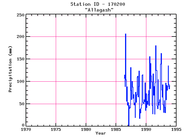
| Name: | ALLAGASH | Lattitude: | 47.07 |
|---|---|---|---|
| Station ID: | 170200 | Longitude: | -69.08 |
| Data Type: | Precipitation (mm) | Elevation: | 181.7 (m) |
| Data Source: | NCDC | Beginning Year: | 1975 |
| State / Province: | ME | Ending Year: | Present |
| Other Close Sites | ||
|---|---|---|
| Data Type | PointID | Name |
| Air Temperature (C) | 170200 | ALLAGASH |
| Stream Discharge (cms) | 01011000 | Allagash River Near Allagash, Me |
| Snowfall (mm) | 170200 | ALLAGASH |
| Download | |
|---|---|
| Site Descriptor Information | Site Time Series Data |
| Point Id | Year | PPT mm | |||||||||||
|---|---|---|---|---|---|---|---|---|---|---|---|---|---|
| Jan | Feb | Mar | Apr | May | Jun | Jul | Aug | Sep | Oct | Nov | Dec | ||
| 170200 | 1970 | ||||||||||||
| 170200 | 1971 | ||||||||||||
| 170200 | 1972 | ||||||||||||
| 170200 | 1973 | ||||||||||||
| 170200 | 1974 | ||||||||||||
| 170200 | 1975 | ||||||||||||
| 170200 | 1976 | ||||||||||||
| 170200 | 1977 | ||||||||||||
| 170200 | 1978 | ||||||||||||
| 170200 | 1979 | ||||||||||||
| 170200 | 1980 | ||||||||||||
| 170200 | 1981 | ||||||||||||
| 170200 | 1982 | ||||||||||||
| 170200 | 1983 | ||||||||||||
| 170200 | 1984 | ||||||||||||
| 170200 | 1985 | ||||||||||||
| 170200 | 1986 | 107 | 114 | 89 | 206 | 104 | 56 | 88 | 47 | ||||
| 170200 | 1987 | 53 | 2 | 46 | 40 | 42 | 131 | 80 | 60 | 101 | 87 | 63 | 71 |
| 170200 | 1988 | 48 | 52 | 20 | 76 | 54 | 70 | 109 | 112 | 66 | 89 | 123 | 18 |
| 170200 | 1989 | 38 | 30 | 41 | 48 | 114 | 115 | 53 | 50 | 59 | 55 | 97 | 36 |
| 170200 | 1990 | 73 | 42 | 56 | 49 | 71 | 80 | 46 | 156 | 84 | 140 | 112 | 99 |
| 170200 | 1991 | 47 | 28 | 117 | 70 | 89 | 27 | 97 | 180 | 125 | 125 | 46 | 39 |
| 170200 | 1992 | 104 | 47 | 53 | 59 | 37 | 139 | 163 | 81 | 65 | 93 | 48 | 31 |
| 170200 | 1993 | 57 | 43 | 30 | 96 | 59 | 91 | 80 | 89 | 135 | 94 | 84 | 91 |


