 |
 |
|
|
|
|
| Name: | Beaver Brook At N. Pelham, Nh | Lattitude: | 42.816666 |
|---|---|---|---|
| Station ID: | 010965852 | Longitude: | -71.349998 |
| Data Type: | Stream Discharge (cms) | Elevation: | |
| Data Source: | USGS | Beginning Year: | |
| State / Province: | NH | Ending Year: |
| Other Close Sites | ||
|---|---|---|
| Data Type | PointID | Name |
| Air Temperature (C) | 279740 | WINDHAM |
| Precipitation (mm) | 279740 | WINDHAM |
| Snowfall (mm) | 279740 | WINDHAM |
| Download | |
|---|---|
| Site Descriptor Information | Site Time Series Data |
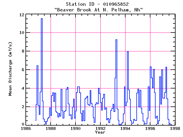
| Point Id | Year | Discharge m3/s | |||||||||||
|---|---|---|---|---|---|---|---|---|---|---|---|---|---|
| Jan | Feb | Mar | Apr | May | Jun | Jul | Aug | Sep | Oct | Nov | Dec | ||
| 010965852 | 1986 | 0.54 | 2.27 | 6.46 | |||||||||
| 010965852 | 1987 | 2.13 | 1.17 | 3.61 | 11.51 | 2.62 | 0.68 | 0.40 | 0.12 | 0.44 | 0.71 | 0.87 | 1.90 |
| 010965852 | 1988 | 1.07 | 3.23 | 3.53 | 2.58 | 3.50 | 1.48 | 1.37 | 0.92 | 1.30 | 0.99 | 3.88 | 1.58 |
| 010965852 | 1989 | 0.78 | 1.49 | 1.60 | 3.89 | 4.10 | 2.32 | 1.09 | 1.16 | 0.70 | 1.99 | 2.84 | 0.79 |
| 010965852 | 1990 | 1.54 | 3.56 | 4.17 | 4.17 | 3.53 | 1.32 | 0.47 | 1.59 | 0.52 | 2.89 | 2.96 | 3.17 |
| 010965852 | 1991 | 2.26 | 2.18 | 3.78 | 2.37 | 2.01 | 0.85 | 0.33 | 2.27 | 2.45 | 2.33 | 4.02 | 3.44 |
| 010965852 | 1992 | 2.47 | 1.65 | 2.93 | 3.37 | 1.74 | 1.90 | 0.59 | 0.75 | 0.30 | 0.68 | 1.61 | 1.82 |
| 010965852 | 1993 | 2.30 | 1.50 | 5.14 | 9.26 | 1.77 | 0.55 | 0.10 | 0.06 | 0.15 | 0.34 | 1.25 | 4.16 |
| 010965852 | 1994 | 2.15 | 2.50 | 7.97 | 3.84 | 2.84 | 0.50 | 0.23 | 0.25 | 0.65 | 0.53 | 0.55 | 3.49 |
| 010965852 | 1995 | 3.94 | 1.97 | 3.79 | 1.87 | 1.31 | 0.47 | 0.24 | 0.16 | 0.17 | 0.77 | 4.18 | 1.63 |
| 010965852 | 1996 | 6.31 | 5.13 | 4.05 | 6.03 | 3.54 | 0.78 | 1.00 | 0.17 | 0.50 | 5.25 | 2.30 | 6.01 |
| 010965852 | 1997 | 2.94 | 2.93 | 3.56 | 6.28 | 2.87 | 0.66 | 0.24 | 0.14 | 0.08 | |||


