 |
 |
|
|
|
|
| Name: | Sandy River Near Farmington, Me | Lattitude: | 44.716667 |
|---|---|---|---|
| Station ID: | 01047500 | Longitude: | -70.183327 |
| Data Type: | Stream Discharge (cms) | Elevation: | |
| Data Source: | USGS | Beginning Year: | |
| State / Province: | ME | Ending Year: |
| Other Close Sites | ||
|---|---|---|
| Data Type | PointID | Name |
| Air Temperature (C) | 172765 | FARMINGTON |
| Precipitation (mm) | 172765 | FARMINGTON |
| Snowfall (mm) | 172765 | FARMINGTON |
| Download | |
|---|---|
| Site Descriptor Information | Site Time Series Data |
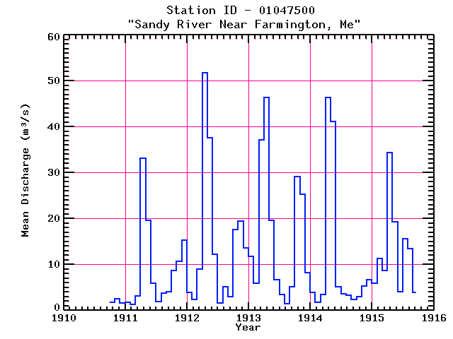
| Point Id | Year | Discharge m3/s | |||||||||||
|---|---|---|---|---|---|---|---|---|---|---|---|---|---|
| Jan | Feb | Mar | Apr | May | Jun | Jul | Aug | Sep | Oct | Nov | Dec | ||
| 01047500 | 1910 | 1.79 | 2.49 | 1.69 | |||||||||
| 01047500 | 1911 | 1.77 | 1.24 | 3.12 | 33.11 | 19.65 | 5.86 | 1.97 | 3.79 | 4.08 | 8.65 | 10.62 | 15.31 |
| 01047500 | 1912 | 3.98 | 2.32 | 9.03 | 51.73 | 37.58 | 12.26 | 1.66 | 5.12 | 3.01 | 17.62 | 19.43 | 13.64 |
| 01047500 | 1913 | 11.73 | 6.00 | 37.10 | 46.43 | 19.56 | 6.75 | 3.41 | 1.44 | 5.20 | 29.22 | 25.31 | 8.23 |
| 01047500 | 1914 | 3.99 | 1.81 | 3.48 | 46.45 | 41.11 | 5.13 | 3.63 | 3.38 | 2.31 | 3.06 | 5.36 | 6.69 |
| 01047500 | 1915 | 5.85 | 11.30 | 8.71 | 34.40 | 19.26 | 4.13 | 15.57 | 13.51 | 3.95 | |||


