 |
 |
|
|
|
|
| Name: | VAN BUREN 2 | Lattitude: | 47.17 |
|---|---|---|---|
| Station ID: | 178965 | Longitude: | -67.95 |
| Data Type: | Air Temperature (C) | Elevation: | 139 (m) |
| Data Source: | NCDC | Beginning Year: | 1963 |
| State / Province: | ME | Ending Year: | Present |
| Other Close Sites | ||
|---|---|---|
| Data Type | PointID | Name |
| Stream Discharge (cms) | 01015000 | St. John River At Van Buren, Me |
| Precipitation (mm) | 178965 | VAN BUREN 2 |
| Snowfall (mm) | 178965 | VAN BUREN 2 |
| Download | |
|---|---|
| Site Descriptor Information | Site Time Series Data |
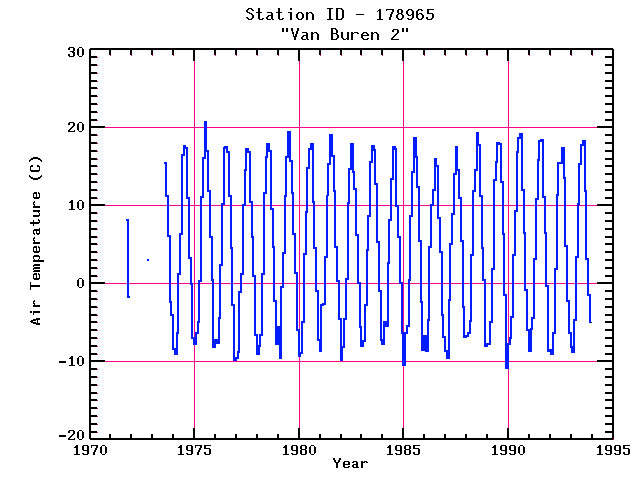
| Point Id | Year | Air Temperature C | |||||||||||
|---|---|---|---|---|---|---|---|---|---|---|---|---|---|
| Jan | Feb | Mar | Apr | May | Jun | Jul | Aug | Sep | Oct | Nov | Dec | ||
| 178965 | 1970 | ||||||||||||
| 178965 | 1971 | 8.2 | -1.7 | ||||||||||
| 178965 | 1972 | 3.0 | |||||||||||
| 178965 | 1973 | 15.4 | 11.2 | 6.1 | -2.4 | -4.1 | |||||||
| 178965 | 1974 | -8.4 | -9.0 | -6.3 | 1.2 | 6.3 | 16.5 | 17.6 | 17.4 | 11.0 | 3.3 | -0.1 | -7.0 |
| 178965 | 1975 | -7.7 | -6.3 | -5.0 | 0.3 | 11.1 | 16.1 | 20.7 | 17.0 | 11.8 | 5.9 | 0.4 | -8.2 |
| 178965 | 1976 | -7.3 | -7.6 | -4.4 | 2.4 | 10.2 | 17.4 | 17.5 | 16.8 | 11.2 | 4.5 | -2.7 | -9.8 |
| 178965 | 1977 | -9.5 | -8.8 | -1.1 | 1.2 | 10.1 | 14.5 | 17.3 | 16.8 | 10.5 | 6.0 | 1.0 | -6.6 |
| 178965 | 1978 | -9.0 | -8.0 | -6.6 | 1.2 | 11.6 | 16.2 | 17.9 | 17.0 | 9.6 | 4.7 | -2.3 | -7.8 |
| 178965 | 1979 | -5.6 | -9.5 | -0.4 | 3.9 | 11.2 | 16.2 | 19.4 | 15.7 | 11.6 | 6.3 | 1.3 | -6.0 |
| 178965 | 1980 | -9.3 | -8.9 | -4.9 | 3.8 | 9.2 | 14.8 | 17.2 | 17.9 | 10.4 | 4.6 | -1.0 | -7.3 |
| 178965 | 1981 | -8.7 | -2.7 | -2.6 | 3.4 | 11.3 | 15.3 | 19.0 | 16.3 | 11.9 | 4.7 | 0.3 | -4.5 |
| 178965 | 1982 | -9.8 | -8.2 | -4.6 | 0.6 | 10.3 | 14.7 | 17.9 | 14.3 | 12.1 | 6.2 | 0.1 | -5.6 |
| 178965 | 1983 | -8.0 | -7.4 | -2.8 | 4.3 | 8.7 | 15.6 | 17.6 | 17.1 | 12.8 | 5.3 | -0.9 | -7.2 |
| 178965 | 1984 | -7.7 | -5.0 | -5.5 | 2.6 | 8.1 | 13.4 | 17.5 | 17.3 | 9.9 | 5.9 | 0.1 | -6.4 |
| 178965 | 1985 | -10.5 | -6.3 | -5.4 | 0.5 | 8.7 | 14.3 | 18.6 | 16.2 | 12.4 | 5.4 | -2.4 | -8.5 |
| 178965 | 1986 | -6.7 | -8.7 | -4.7 | 4.7 | 10.1 | 12.0 | 15.9 | 15.1 | 8.4 | 4.0 | -4.0 | -6.8 |
| 178965 | 1987 | -8.7 | -9.6 | -2.1 | 5.1 | 8.9 | 14.1 | 17.5 | 14.6 | 10.9 | 5.5 | -3.0 | -6.8 |
| 178965 | 1988 | -6.7 | -6.4 | -4.8 | 3.7 | 11.8 | 14.5 | 19.3 | 17.8 | 11.2 | 4.5 | 0.4 | -8.0 |
| 178965 | 1989 | -7.7 | -7.7 | -5.0 | 1.8 | 13.3 | 15.6 | 18.0 | 17.9 | 13.0 | 6.3 | -1.5 | -10.8 |
| 178965 | 1990 | -7.7 | -7.0 | -4.3 | 3.6 | 9.3 | 16.8 | 18.6 | 19.2 | 12.0 | 6.5 | -0.8 | -5.9 |
| 178965 | 1991 | -8.7 | -5.8 | -4.4 | 3.1 | 10.8 | 15.8 | 18.3 | 18.4 | 11.1 | 6.5 | -0.3 | -8.7 |
| 178965 | 1992 | -8.5 | -9.0 | -6.4 | 1.9 | 11.4 | 15.5 | 15.5 | 17.4 | 13.5 | 4.8 | -2.2 | -6.4 |
| 178965 | 1993 | -8.1 | -8.8 | -4.7 | 3.4 | 10.2 | 15.3 | 17.7 | 18.3 | 11.8 | 3.2 | -1.5 | -4.9 |


